
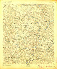
~ Jasper AL topo map, 1:125000 scale, 30 X 30 Minute, Historical, 1893, updated 1921
Jasper, Alabama, USGS topographic map dated 1893.
Includes geographic coordinates (latitude and longitude). This topographic map is suitable for hiking, camping, and exploring, or framing it as a wall map.
Printed on-demand using high resolution imagery, on heavy weight and acid free paper, or alternatively on a variety of synthetic materials.
Topos available on paper, Waterproof, Poly, or Tyvek. Usually shipping rolled, unless combined with other folded maps in one order.
- Product Number: USGS-5542773
- Free digital map download (high-resolution, GeoPDF): Jasper, Alabama (file size: 9 MB)
- Map Size: please refer to the dimensions of the GeoPDF map above
- Weight (paper map): ca. 55 grams
- Map Type: POD USGS Topographic Map
- Map Series: HTMC
- Map Verison: Historical
- Cell ID: 65753
- Scan ID: 305857
- Imprint Year: 1921
- Survey Year: 1891
- Datum: Unstated
- Map Projection: Unstated
- Map published by United States Geological Survey
- Map Language: English
- Scanner Resolution: 600 dpi
- Map Cell Name: Jasper
- Grid size: 30 X 30 Minute
- Date on map: 1893
- Map Scale: 1:125000
- Geographical region: Alabama, United States
Neighboring Maps:
All neighboring USGS topo maps are available for sale online at a variety of scales.
Spatial coverage:
Topo map Jasper, Alabama, covers the geographical area associated the following places:
- Whitson - Nauvoo - Barney - Port Birmingham - Powellville - Hudson Settlement - Red Star - Driftwood - Bethel - Wilburn - Edgil - Quintown - Pumpkin Center - McCollum - Sylvan Springs - Sandtown - Gilmore - Benoit - Campbellville - Fairview - Camak Mills (historical) - Pleasant Grove - Uptain Mobile Home Park - Reeds Ferry - Pennsylvania Camp (historical) - Coon Creek - Alliance - Bradleytown - Williamsburg - Porter - Dixie Springs - Hayes Crossing - Dovertown - Lake Shore Subdivision - Sumiton - Burrows Crossroads - Crews Mobile Home Park - Williamstown - Oakman - Enoe - Twilley Town - Argo - Patton - Sloss - Labuco - Gamble - Saragossa - Petes Crossroads - Mountain Valley (historical) - Marietta - Wilderness Garden - Hudson Mobile Home Park - Tutwiler - Madison Mobile Home Park - West Corona - Red Rock - Marylee - Mount Hope - Lockhart (historical) - Bryan - Lone Oak Subdivision - Drifton - Hilliard - Key Hill - Manchester - Cold Springs - Empire - Littletons - Gayosa - New Jagger - Five Points - Shady Grove - Dora Junction - Pine Tree Trailer Park - Ardell - Chapel Hill - Corona - Hillsdale - Hull - Briarcliff Estates - Providence - Stephenson Crossing - Riverside Estates - Goodsprings - Short Creek - Praco - Deason Hill - Dora - Hoagtown - Salem - Crestview Estates - Little Shoal - Samoset - Pleasant Field - Sardis - Kershaw - Sunlight - Aldridge - Gardiners Gin - Three Forks
- Map Area ID: AREA3433.5-87.5-87
- Northwest corner Lat/Long code: USGSNW34-87.5
- Northeast corner Lat/Long code: USGSNE34-87
- Southwest corner Lat/Long code: USGSSW33.5-87.5
- Southeast corner Lat/Long code: USGSSE33.5-87
- Northern map edge Latitude: 34
- Southern map edge Latitude: 33.5
- Western map edge Longitude: -87.5
- Eastern map edge Longitude: -87


