
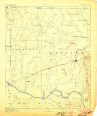
~ Huntsville AL topo map, 1:125000 scale, 30 X 30 Minute, Historical, 1892, updated 1903
Huntsville, Alabama, USGS topographic map dated 1892.
Includes geographic coordinates (latitude and longitude). This topographic map is suitable for hiking, camping, and exploring, or framing it as a wall map.
Printed on-demand using high resolution imagery, on heavy weight and acid free paper, or alternatively on a variety of synthetic materials.
Topos available on paper, Waterproof, Poly, or Tyvek. Usually shipping rolled, unless combined with other folded maps in one order.
- Product Number: USGS-5542761
- Free digital map download (high-resolution, GeoPDF): Huntsville, Alabama (file size: 5 MB)
- Map Size: please refer to the dimensions of the GeoPDF map above
- Weight (paper map): ca. 55 grams
- Map Type: POD USGS Topographic Map
- Map Series: HTMC
- Map Verison: Historical
- Cell ID: 65719
- Scan ID: 305850
- Imprint Year: 1903
- Survey Year: 1885
- Datum: Unstated
- Map Projection: Unstated
- Map published by United States Geological Survey
- Map Language: English
- Scanner Resolution: 600 dpi
- Map Cell Name: Huntsville
- Grid size: 30 X 30 Minute
- Date on map: 1892
- Map Scale: 1:125000
- Geographical region: Alabama, United States
Neighboring Maps:
All neighboring USGS topo maps are available for sale online at a variety of scales.
Spatial coverage:
Topo map Huntsville, Alabama, covers the geographical area associated the following places:
- Cottonwood - Maplewood - Locke Crossroads - Sardis Springs - Piedmont - Stone Ridge - Fairview - Kildere Estates - West Decatur - Lakewood - Bobo - Mountain Heights - Laceys Spring - Meadow Hills - Scenic View - Cedar Valley - Bravo - Hillview Acres - Greenbriar - Burrows - Rainbow Mountain Heights - Six Way - Chapman Heights - Wooley Springs (historical) - Salem Corner - Talucah - Fairview - Willow Bend - East Limestone - Brookwood Forest - Huntsville Hills - Elko - Batts Heights - Alabama Fork - Northwood - Haden - Burningtree Mountain - Ryland Acres - Fairmount - Five Points - Hickory Hills - Decatur - Holland Gin - Bethel - Oakland - Lakewood Manor - West Huntsville - Moores Mill - Lynwood Gardens - English Terrace - Oak Leaf - Pearsall Gardens - Norton - Madison - Brentwood - English Village - Whiteside - Gentily Forest - Valley Park - Normal - Pine Dale - Tanner Crossroads - Madison Highlands - Winslow - The Woodlands - Tanner - South Gate - Glen Park - Vaughn Corners - Greenhill - Rainbow Gap Estates - Edgemont - Vestavia Estates - Bel Air Estates - Toney - Chase - Elkwood - Russell Village - Bucks Mill - Skinem - Browns Corner - Westbury - Mountain Gap Estates - Copeland - Hillwood - Swancott - Ridgewood - Irvington - Hillandale - Murphree Place - Capshaw - Tannahill Estates - Stag Run - Brandontown - Davis Hills - Colonial Hills - Estaville (historical) - Crowtown - Byram Heights - New Haven
- Map Area ID: AREA3534.5-87-86.5
- Northwest corner Lat/Long code: USGSNW35-87
- Northeast corner Lat/Long code: USGSNE35-86.5
- Southwest corner Lat/Long code: USGSSW34.5-87
- Southeast corner Lat/Long code: USGSSE34.5-86.5
- Northern map edge Latitude: 35
- Southern map edge Latitude: 34.5
- Western map edge Longitude: -87
- Eastern map edge Longitude: -86.5


