
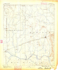
~ Huntsville AL topo map, 1:125000 scale, 30 X 30 Minute, Historical, 1888
Huntsville, Alabama, USGS topographic map dated 1888.
Includes geographic coordinates (latitude and longitude). This topographic map is suitable for hiking, camping, and exploring, or framing it as a wall map.
Printed on-demand using high resolution imagery, on heavy weight and acid free paper, or alternatively on a variety of synthetic materials.
Topos available on paper, Waterproof, Poly, or Tyvek. Usually shipping rolled, unless combined with other folded maps in one order.
- Product Number: USGS-5542755
- Free digital map download (high-resolution, GeoPDF): Huntsville, Alabama (file size: 5 MB)
- Map Size: please refer to the dimensions of the GeoPDF map above
- Weight (paper map): ca. 55 grams
- Map Type: POD USGS Topographic Map
- Map Series: HTMC
- Map Verison: Historical
- Cell ID: 65719
- Scan ID: 305847
- Survey Year: 1885
- Datum: Unstated
- Map Projection: Unstated
- Map published by United States Geological Survey
- Map Language: English
- Scanner Resolution: 600 dpi
- Map Cell Name: Huntsville
- Grid size: 30 X 30 Minute
- Date on map: 1888
- Map Scale: 1:125000
- Geographical region: Alabama, United States
Neighboring Maps:
All neighboring USGS topo maps are available for sale online at a variety of scales.
Spatial coverage:
Topo map Huntsville, Alabama, covers the geographical area associated the following places:
- Pleasant Acres - Grove View Acres - Dallas - Carey - Lakewood Manor - Sulphur Springs - Sherwood Park - Crowtown - Belview Heights - Chimney Springs - Double Tree - Holland Place - Lakewood - New Hope - Union Park - Garner (historical) - Greenbrier - Country Village - Elko - Morris Crossroads - Cave Springs - Mountain Gap Estates - Vestavia Estates - Grove Park - Burgreen Gin - Meridianville - Center Hill - Cluttsville - Whitfield - Cloverleaf - Crestview Estates - Willow Bend - Greenhill - Stag Run - Priceville - Capshaw - Tanner Crossroads - Bellemeade - Brookwood - Bluff City - Pettusville - Redstone Park - Oak Park - Alabama Fork - Hickory Hills - Skyline Acres - Oakwood - State Line - Lake Ida Heights - Wigginsville - Keys Mill - Sand Spring (historical) - Willowbrook Estates - Lakewood - Bel Air Estates - Talucah - Rutledge Heights - Hoover - University Park - Meadow Lane Estates - Belle Mina - Oak Leaf - Burningtree Estates - Country Village - Fisk - Greenwycke Village - Hillview Acres - Toney - Westlawn - Belmont - Bucks Canyon - Maple Hill - Vaughn Corners - Mooresville - Bethel - Scenic View - Sweetwater - Madison - Mayflower - Meadow Hills - Pinedale Acres - Cottonwood - Meadow Trace - Camelot - Mayfair - Rolling Woods - Peets Corner - Madison Point - Albany - Glen Park - Tara - Sunset Cove - Rideout Village - Orrville - Western Hills Estates - Gladstone - Woodfin Mill - Echols Crossroads - Pine Dale - Bravo
- Map Area ID: AREA3534.5-87-86.5
- Northwest corner Lat/Long code: USGSNW35-87
- Northeast corner Lat/Long code: USGSNE35-86.5
- Southwest corner Lat/Long code: USGSSW34.5-87
- Southeast corner Lat/Long code: USGSSE34.5-86.5
- Northern map edge Latitude: 35
- Southern map edge Latitude: 34.5
- Western map edge Longitude: -87
- Eastern map edge Longitude: -86.5


