
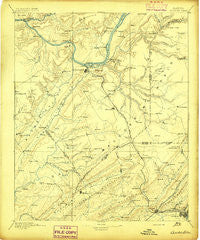
~ Gadsden AL topo map, 1:125000 scale, 30 X 30 Minute, Historical, 1895
Gadsden, Alabama, USGS topographic map dated 1895.
Includes geographic coordinates (latitude and longitude). This topographic map is suitable for hiking, camping, and exploring, or framing it as a wall map.
Printed on-demand using high resolution imagery, on heavy weight and acid free paper, or alternatively on a variety of synthetic materials.
Topos available on paper, Waterproof, Poly, or Tyvek. Usually shipping rolled, unless combined with other folded maps in one order.
- Product Number: USGS-5542749
- Free digital map download (high-resolution, GeoPDF): Gadsden, Alabama (file size: 7 MB)
- Map Size: please refer to the dimensions of the GeoPDF map above
- Weight (paper map): ca. 55 grams
- Map Type: POD USGS Topographic Map
- Map Series: HTMC
- Map Verison: Historical
- Cell ID: 65531
- Scan ID: 305844
- Survey Year: 1885
- Datum: Unstated
- Map Projection: Unstated
- Map published by United States Geological Survey
- Map Language: English
- Scanner Resolution: 600 dpi
- Map Cell Name: Gadsden
- Grid size: 30 X 30 Minute
- Date on map: 1895
- Map Scale: 1:125000
- Geographical region: Alabama, United States
Neighboring Maps:
All neighboring USGS topo maps are available for sale online at a variety of scales.
Spatial coverage:
Topo map Gadsden, Alabama, covers the geographical area associated the following places:
- Ellison Crossroads - Rollins (historical) - Lane - Craig (historical) - Corbinville - Bowen (historical) - Crudup - Highmound - South Gadsden - McLarty - Mount Carmel - Arab - Mays - McVille - Summit - Rains (historical) - Fridays Crossing - Mount Hebron - Norton - Marshall - Lindsay Lane - Fenton - Bartlett (historical) - Meadow Wood - Rodentown - Hopper - Rockledge - Rayburn - Mill Village - White Oak - Cottonville - Pine Shores - Happy Hill - Morton (historical) - Big Spring (historical) - Signal Point Subdivision - Wynnville - Altoona - Fowler (historical) - Five Forks - Chigger Hill - Alice - Pendergrass (historical) - Friendship (historical) - Maryville - Hyatt - Union - Ridgeville - Peters (historical) - Boaz - Double Bridges - Johnson - Royse (historical) - Pleasant Hill - Southtown - New Home - Rabbit Town - Claysville - Midway - Schuler (historical) - Glen Haven - Littleton - Hopewell - Union Grove - Scant City - Lot (historical) - Shady Grove - Greer (historical) - Needmore - Bird (historical) - Phillips (historical) - Pine Acres - Snead - Warrenton Subdivision - Haworth (historical) - Holiday Shores - Rhea (historical) - Warrenton - Carlisle - Pull Tight (historical) - Hortons Mill - Bennettsville (historical) - Pendergrass - Minorville (historical) - Point of Pines Subdivision - Moragne - Martling - Five Points - Scenic Heights - Sherwood Forest - Sidney - New Canaan - Arona - Street (historical) - Crossroads - Saratoga - Pulltight - Nixon Chapel - Liberty - Kilpatrick
- Map Area ID: AREA34.534-86.5-86
- Northwest corner Lat/Long code: USGSNW34.5-86.5
- Northeast corner Lat/Long code: USGSNE34.5-86
- Southwest corner Lat/Long code: USGSSW34-86.5
- Southeast corner Lat/Long code: USGSSE34-86
- Northern map edge Latitude: 34.5
- Southern map edge Latitude: 34
- Western map edge Longitude: -86.5
- Eastern map edge Longitude: -86


