
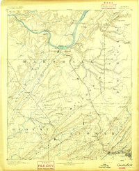
~ Gadsden AL topo map, 1:125000 scale, 30 X 30 Minute, Historical, 1892
Gadsden, Alabama, USGS topographic map dated 1892.
Includes geographic coordinates (latitude and longitude). This topographic map is suitable for hiking, camping, and exploring, or framing it as a wall map.
Printed on-demand using high resolution imagery, on heavy weight and acid free paper, or alternatively on a variety of synthetic materials.
Topos available on paper, Waterproof, Poly, or Tyvek. Usually shipping rolled, unless combined with other folded maps in one order.
- Product Number: USGS-5542747
- Free digital map download (high-resolution, GeoPDF): Gadsden, Alabama (file size: 6 MB)
- Map Size: please refer to the dimensions of the GeoPDF map above
- Weight (paper map): ca. 55 grams
- Map Type: POD USGS Topographic Map
- Map Series: HTMC
- Map Verison: Historical
- Cell ID: 65531
- Scan ID: 305843
- Survey Year: 1885
- Datum: Unstated
- Map Projection: Unstated
- Map published by United States Geological Survey
- Map Language: English
- Scanner Resolution: 600 dpi
- Map Cell Name: Gadsden
- Grid size: 30 X 30 Minute
- Date on map: 1892
- Map Scale: 1:125000
- Geographical region: Alabama, United States
Neighboring Maps:
All neighboring USGS topo maps are available for sale online at a variety of scales.
Spatial coverage:
Topo map Gadsden, Alabama, covers the geographical area associated the following places:
- Liberty - Pine Grove - Sherwood Forest - Warrenton Subdivision - Pine Island Subdivision - Diamond - Manchester - Midway - Summit - Buck Island Shores - Painter - Stowers Hill - Minorville (historical) - Reedbrake (historical) - Moragne - South Gadsden - Johnsons Mill - Egypt - Altoona - Holiday Shores - Ellison Crossroads - Nixon Chapel - Bennettsville (historical) - Agricola - Pleasant Grove - Hendrix - Susan Moore - Mountain View - Schuler (historical) - Fowler (historical) - Warrenton - Pleasant Valley - Monte Vista - Pinedale Shores - Black Creek Falls (historical) - White Oak - Wynnville - Wyeth City - Pine Shores - Hebron - Snead - Tuckahoe Heights - Douglas - Alder Springs - Oak Hill - Royse (historical) - Poplar Springs - Asbury - Tanglewood - Aurora - Happy Hill - Doolans - Walnut Grove - Pendergrass - Stanfield (historical) - Reece City - Hopewell - Chigger Hill - Phillips (historical) - Smith Institute - Point of Pines Subdivision - Black Center - Albertville - Carlisle - Pleasant Hill - Double Bridges - Thrasher Crossroads - Mount Hebron - Redbud - Rayburn - Hyatt - Hopewell - Leath Gap (historical) - Big Spring (historical) - Buck Island Subdivision - Cottonville - Rains (historical) - Red Hill - Lewin (historical) - Union Grove - Rogers - Riverside - Highmound - New Canaan - Pulltight - Haworth (historical) - Sandy Point Subdivision - Shady Acres - Whitesboro - Big Spring Creek Subdivision - Five Points - Whiton - Guntersville Shores - McLarty - Johnson - Johnson (historical) - Playground Shores - Hortons Mill - Star Point Subdivision - Greer (historical)
- Map Area ID: AREA34.534-86.5-86
- Northwest corner Lat/Long code: USGSNW34.5-86.5
- Northeast corner Lat/Long code: USGSNE34.5-86
- Southwest corner Lat/Long code: USGSSW34-86.5
- Southeast corner Lat/Long code: USGSSE34-86
- Northern map edge Latitude: 34.5
- Southern map edge Latitude: 34
- Western map edge Longitude: -86.5
- Eastern map edge Longitude: -86


