
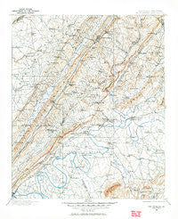
~ Fort Payne AL topo map, 1:125000 scale, 30 X 30 Minute, Historical, 1898, updated 1964
Fort Payne, Alabama, USGS topographic map dated 1898.
Includes geographic coordinates (latitude and longitude). This topographic map is suitable for hiking, camping, and exploring, or framing it as a wall map.
Printed on-demand using high resolution imagery, on heavy weight and acid free paper, or alternatively on a variety of synthetic materials.
Topos available on paper, Waterproof, Poly, or Tyvek. Usually shipping rolled, unless combined with other folded maps in one order.
- Product Number: USGS-5542729
- Free digital map download (high-resolution, GeoPDF): Fort Payne, Alabama (file size: 9 MB)
- Map Size: please refer to the dimensions of the GeoPDF map above
- Weight (paper map): ca. 55 grams
- Map Type: POD USGS Topographic Map
- Map Series: HTMC
- Map Verison: Historical
- Cell ID: 65507
- Scan ID: 305834
- Imprint Year: 1964
- Survey Year: 1898
- Datum: NAD27
- Map Projection: Polyconic
- Map published by United States Geological Survey
- Map Language: English
- Scanner Resolution: 600 dpi
- Map Cell Name: Fort Payne
- Grid size: 30 X 30 Minute
- Date on map: 1898
- Map Scale: 1:125000
- Geographical region: Alabama, United States
Neighboring Maps:
All neighboring USGS topo maps are available for sale online at a variety of scales.
Spatial coverage:
Topo map Fort Payne, Alabama, covers the geographical area associated the following places:
- Fort Payne - Billy Goat Hill - Tucker Crossroads - Mountain Acres - Bath Springs - Lydia - Minvale - Yellow Creek View Subdivision - Wills Valley - Clyde (historical) - Luke - Chavies - McElrath Subdivision - Griffin - Noojinsville - Sanford Springs - Weiss Dam - Bomar - Copeland Bridge - Waterloo Springs - Rawlingsville (historical) - Moshat - Pine Ridge - Horton - Fyffe - Cornwall - Mountain Lake Estates - Noah - Willstown (historical) - Chesterfield - Pleasant Hill - East Gadsden - Flanders - Broomtown - Grassland - Sterling (historical) - Black Creek - Dewey - Marcus (historical) - Banner (historical) - Hooks Lake Subdivision - Pope - Cotnam (historical) - Leonard - Five Points - Centre - Bootsville (historical) - Lookout Valley Acres - Fairview - New Moon - Northside - Hendrixville - Lickskillet - Oak Hill (historical) - Hale (historical) - Ewing - Murrycross - Ricks (historical) - Citico - Ellisville - Tabor - Hendrickville (historical) - Peeks Corner - Pumpkin Center - Larimore (historical) - Roberts Subdivision - Douglas - Grover - Pope - Ferguson - Lawrence - Elrath - Newberry Crossroads - Fisher Crossroads - Floy (historical) - Blanche - Luna (historical) - Ringgold - Antioch Estates - Scrougeout - Homer (historical) - Cornwall Furnace - Sand Rock - Richardson - Wilsons (historical) - Mount Zion (historical) - Whorton - Coosa River Subdivision - Turkey Town (historical) - Lakeview - Ball Flat - Greenwood - Lebanon - Burgess - Watson - Lands Crossroads - Maynard - Yancy - Mount Vernon - Shiloh
- Map Area ID: AREA34.534-86-85.5
- Northwest corner Lat/Long code: USGSNW34.5-86
- Northeast corner Lat/Long code: USGSNE34.5-85.5
- Southwest corner Lat/Long code: USGSSW34-86
- Southeast corner Lat/Long code: USGSSE34-85.5
- Northern map edge Latitude: 34.5
- Southern map edge Latitude: 34
- Western map edge Longitude: -86
- Eastern map edge Longitude: -85.5


