
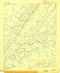
~ Fort Payne AL topo map, 1:125000 scale, 30 X 30 Minute, Historical, 1893
Fort Payne, Alabama, USGS topographic map dated 1893.
Includes geographic coordinates (latitude and longitude). This topographic map is suitable for hiking, camping, and exploring, or framing it as a wall map.
Printed on-demand using high resolution imagery, on heavy weight and acid free paper, or alternatively on a variety of synthetic materials.
Topos available on paper, Waterproof, Poly, or Tyvek. Usually shipping rolled, unless combined with other folded maps in one order.
- Product Number: USGS-5542727
- Free digital map download (high-resolution, GeoPDF): Fort Payne, Alabama (file size: 6 MB)
- Map Size: please refer to the dimensions of the GeoPDF map above
- Weight (paper map): ca. 55 grams
- Map Type: POD USGS Topographic Map
- Map Series: HTMC
- Map Verison: Historical
- Cell ID: 65507
- Scan ID: 305833
- Survey Year: 1884
- Datum: Unstated
- Map Projection: Unstated
- Map published by United States Geological Survey
- Map Language: English
- Scanner Resolution: 600 dpi
- Map Cell Name: Fort Payne
- Grid size: 30 X 30 Minute
- Date on map: 1893
- Map Scale: 1:125000
- Geographical region: Alabama, United States
Neighboring Maps:
All neighboring USGS topo maps are available for sale online at a variety of scales.
Spatial coverage:
Topo map Fort Payne, Alabama, covers the geographical area associated the following places:
- Dixon Shop - Alexis - Hendrixville - Blanche - Pine Grove - Brice - Key - Pine Grove (historical) - Willstown (historical) - Hooks Lake Subdivision - Edwardsville - McElrath Subdivision - Mount Zion (historical) - Daisy - Howells Crossroads - Pine Ridge - Broomtown - Loop - Sand Rock - Plano - Burkhalter Subdivision - Fort Payne - Chavies - Turkeytown - Brooks Estates - Portersville - Coosa River Subdivision - McKestes - Exie - Mount Vernon - Bath Springs - Floy (historical) - Gilbert Crossroads - Moshat - Bomar - Chumley (historical) - Lebanon - Leesburg - Copeland Bridge - Lydia - Anderson - Douglas - Ricks (historical) - Loveless - Fisher Crossroads - Alpine Shores - Kings Hill (historical) - Murrycross - Maple Grove - Lands Crossroads - Dawson - Northwood Estates - Luttrell - Newberry Cove - Antioch Estates - Centre - McGhee - Sigsbee - Ferguson - Tabor - Greenwood - East Gadsden - Maynard - Pope - Guest - Collinsville - Slackland - Luke - Five Points - Cornwall - Bay View Estates - Ophir - Duck Springs - Summer Estates - Billy Goat Hill - Sanford Springs - Blue Pond - Pathkiller Cove - Noah - Jamestown - Anderson - Black Creek - Fairview - Waterloo Springs - Yancy - Adamsburg - Gibson Crossroads - Skirum - Pleasant Hill - Ewing - Keener - Tennala - Minvale - Watson - Powell - Ringgold - Dewey - Grassland - Elrath - Shangrila
- Map Area ID: AREA34.534-86-85.5
- Northwest corner Lat/Long code: USGSNW34.5-86
- Northeast corner Lat/Long code: USGSNE34.5-85.5
- Southwest corner Lat/Long code: USGSSW34-86
- Southeast corner Lat/Long code: USGSSE34-85.5
- Northern map edge Latitude: 34.5
- Southern map edge Latitude: 34
- Western map edge Longitude: -86
- Eastern map edge Longitude: -85.5


