
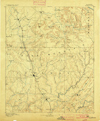
~ Cullman AL topo map, 1:125000 scale, 30 X 30 Minute, Historical, 1892, updated 1900
Cullman, Alabama, USGS topographic map dated 1892.
Includes geographic coordinates (latitude and longitude). This topographic map is suitable for hiking, camping, and exploring, or framing it as a wall map.
Printed on-demand using high resolution imagery, on heavy weight and acid free paper, or alternatively on a variety of synthetic materials.
Topos available on paper, Waterproof, Poly, or Tyvek. Usually shipping rolled, unless combined with other folded maps in one order.
- Product Number: USGS-5542713
- Free digital map download (high-resolution, GeoPDF): Cullman, Alabama (file size: 8 MB)
- Map Size: please refer to the dimensions of the GeoPDF map above
- Weight (paper map): ca. 55 grams
- Map Type: POD USGS Topographic Map
- Map Series: HTMC
- Map Verison: Historical
- Cell ID: 65300
- Scan ID: 305824
- Imprint Year: 1900
- Survey Year: 1885
- Datum: Unstated
- Map Projection: Unstated
- Map published by United States Geological Survey
- Map Language: English
- Scanner Resolution: 600 dpi
- Map Cell Name: Cullman
- Grid size: 30 X 30 Minute
- Date on map: 1892
- Map Scale: 1:125000
- Geographical region: Alabama, United States
Neighboring Maps:
All neighboring USGS topo maps are available for sale online at a variety of scales.
Spatial coverage:
Topo map Cullman, Alabama, covers the geographical area associated the following places:
- Northwood - Fairview West - Lynntown - Pleasant Ridge - Blue Springs - Turney Crossroads - Mount View - Union Grove - Lacon - Steppville - Liberty - Five Points - Johnsons Crossing - Welti - Union Hill - Cullman - County Line - Fairview - Pine Acres - Wilhites - Morgan City - Union - Oak Ridge - Grandview - Cedar Plains - Mount Olive - Garden City - Baileyton - Battleground - Sunset Acres - New Harmony - Dodge City - Georgia - Baldwin - Trimble - Dyers Crossroads - Meadowood - West Point - Fowler Spring - Longview - Union Hill - Vinemont - Briscoe - Sky Ball - River Bend - Six Mile - Egypt - Joppa - Clemons Crossroad - West Point - Carrol Acres - Center Grove - Phelan - Bethel - Birdsong - Cole Spring - Royal - Hog Jaw - Oden Ridge - Allens Crossroads - Center Hill - North Walter - Bolte - Winn Crossroads - Woodland Mills - Eddy - Centerville - Apple Grove - Gold Ridge - May Apple (historical) - Chamblees Mill - Birdie - Brooklyn - Simcoe - South Vinemont - Baileytown - Joy - Holly Pond - New Hope - Stringer - Wesoda - Smithdale - Pine Hill - Enon - Bell Springs - Roswell - Peach Grove (historical) - Ryan Crossroads - North Arab - New Hope - Florette - North Vinemont - Southern (historical) - Pence - Providence - Center Community - Henderson - Rock Springs - Tanner Heights - Hulaco
- Map Area ID: AREA34.534-87-86.5
- Northwest corner Lat/Long code: USGSNW34.5-87
- Northeast corner Lat/Long code: USGSNE34.5-86.5
- Southwest corner Lat/Long code: USGSSW34-87
- Southeast corner Lat/Long code: USGSSE34-86.5
- Northern map edge Latitude: 34.5
- Southern map edge Latitude: 34
- Western map edge Longitude: -87
- Eastern map edge Longitude: -86.5


