
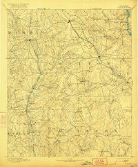
~ Clanton AL topo map, 1:125000 scale, 30 X 30 Minute, Historical, 1891, updated 1921
Clanton, Alabama, USGS topographic map dated 1891.
Includes geographic coordinates (latitude and longitude). This topographic map is suitable for hiking, camping, and exploring, or framing it as a wall map.
Printed on-demand using high resolution imagery, on heavy weight and acid free paper, or alternatively on a variety of synthetic materials.
Topos available on paper, Waterproof, Poly, or Tyvek. Usually shipping rolled, unless combined with other folded maps in one order.
- Product Number: USGS-5542707
- Free digital map download (high-resolution, GeoPDF): Clanton, Alabama (file size: 7 MB)
- Map Size: please refer to the dimensions of the GeoPDF map above
- Weight (paper map): ca. 55 grams
- Map Type: POD USGS Topographic Map
- Map Series: HTMC
- Map Verison: Historical
- Cell ID: 65210
- Scan ID: 305821
- Imprint Year: 1921
- Survey Year: 1889
- Datum: Unstated
- Map Projection: Unstated
- Map published by United States Geological Survey
- Map Language: English
- Scanner Resolution: 600 dpi
- Map Cell Name: Clanton
- Grid size: 30 X 30 Minute
- Date on map: 1891
- Map Scale: 1:125000
- Geographical region: Alabama, United States
Neighboring Maps:
All neighboring USGS topo maps are available for sale online at a variety of scales.
Spatial coverage:
Topo map Clanton, Alabama, covers the geographical area associated the following places:
- Hubbard - Billingsley - Oak Grove - Thomas Mill - Adams - Lawley - Oakley - Maud - Fairview - Bethel Grove - Gibbons (historical) - Verbena - Bonita - Antioch - Parnell - Hillside (historical) - Milton - Mineral Springs - Beth Grove (historical) - Vine Hill - Pleasant Grove - Poseys Crossroads - Dixie - Collins Chapel - New Convert - Vida Junction - Riderville - Jumbo - Browntown - Pools Crossroads - Thorsby - Active - Gap of the Mountain - Maplesville - Bessie - Pletcher - Mars Hill - Clanton - Valley Creek Junction - Evergreen - White City - Lomax - Center Hill - Vida - Poseys Crossroads - Fremont - Stanton - Kincheon - Plantersville - Bibb Mill - Mulberry - Randolph - Rocky Mount - Cooper - Joffre - Booth - Union Grove - Old Kingston - Falakto - Independence - Cox - Oak Grove - Haynes - Jones - Tucker - Highland - Mount Sinai - Enterprise - New Prospect - Winslow - Jemison - Isabella - Sand Mountain - Campbell - Spur (historical) - Kalona - Samaria - Valley Grande
- Map Area ID: AREA3332.5-87-86.5
- Northwest corner Lat/Long code: USGSNW33-87
- Northeast corner Lat/Long code: USGSNE33-86.5
- Southwest corner Lat/Long code: USGSSW32.5-87
- Southeast corner Lat/Long code: USGSSE32.5-86.5
- Northern map edge Latitude: 33
- Southern map edge Latitude: 32.5
- Western map edge Longitude: -87
- Eastern map edge Longitude: -86.5


