
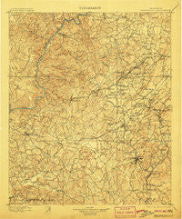
~ Brookwood AL topo map, 1:125000 scale, 30 X 30 Minute, Historical, 1899, updated 1906
Brookwood, Alabama, USGS topographic map dated 1899.
Includes geographic coordinates (latitude and longitude). This topographic map is suitable for hiking, camping, and exploring, or framing it as a wall map.
Printed on-demand using high resolution imagery, on heavy weight and acid free paper, or alternatively on a variety of synthetic materials.
Topos available on paper, Waterproof, Poly, or Tyvek. Usually shipping rolled, unless combined with other folded maps in one order.
- Product Number: USGS-5542693
- Free digital map download (high-resolution, GeoPDF): Brookwood, Alabama (file size: 11 MB)
- Map Size: please refer to the dimensions of the GeoPDF map above
- Weight (paper map): ca. 55 grams
- Map Type: POD USGS Topographic Map
- Map Series: HTMC
- Map Verison: Historical
- Cell ID: 65065
- Scan ID: 305814
- Imprint Year: 1906
- Survey Year: 1895
- Datum: Unstated
- Map Projection: Unstated
- Map published by United States Geological Survey
- Map Language: English
- Scanner Resolution: 600 dpi
- Map Cell Name: Brookwood
- Grid size: 30 X 30 Minute
- Date on map: 1899
- Map Scale: 1:125000
- Geographical region: Alabama, United States
Neighboring Maps:
All neighboring USGS topo maps are available for sale online at a variety of scales.
Spatial coverage:
Topo map Brookwood, Alabama, covers the geographical area associated the following places:
- Burchfield - Fleetwood - Nichol Hills - Hargrove (historical) - Black Diamond - Flint Hill - Briarwood - Cedar Cove - Blocton (historical) - Piper - Tannehill Valley Estates - West Blocton - Ardela (historical) - Bucktown (historical) - New Hargrove (historical) - Hillsdale - Norris Circle - Johns - Stewart Settlement - Brentwood - Clyde Jones Subdivision - Harmon - Sumter - Summerfield - Druid Hills - Green Grove - Abernant - North Johns - Johnstown - Lakeridge - McAdory - Corinne (historical) - East Park - Cadillac Estates - Altamont - Vines Mill - Grimes - Smith Hill - Lowerytown - Blue Creek - Monticello Estates - Duncanville - Primitive Ridge - Marvel - Italian Town - Burmah (historical) - Bull City - Little Hope - Walker Subdivision - McCalla - High Point - Elm Ridge - Canyon Lakes - Eastern Hills - Virginia - Laurel Hills - Coaling - Toadvine - Howton - Pilgrim Rest (historical) - Belchers - Woodland Pines - The Staffords - Lawsontown - Hagler - Giles - Woodland Park - River Bend (historical) - Klondike - Mayfair - Windham Springs - Old Mill Trace - Peach Grove - Asbury - Rock Creek - Red Eagle - Shawtown - Cherrywood - Claymont - Norris Estates - Kimbrell - Coleanor - Dowdle - McCulley Creek - Pattersontown - Chambers - Alpine Hills - Keenewood - Academy Park - Three Branches Estates - Monte Vista - Gray Hill - Cumberland Park - Banks Villa East - Huntland - Holt - Kellerman - Arcadia - Docray - Kyles Subdivision
- Map Area ID: AREA33.533-87.5-87
- Northwest corner Lat/Long code: USGSNW33.5-87.5
- Northeast corner Lat/Long code: USGSNE33.5-87
- Southwest corner Lat/Long code: USGSSW33-87.5
- Southeast corner Lat/Long code: USGSSE33-87
- Northern map edge Latitude: 33.5
- Southern map edge Latitude: 33
- Western map edge Longitude: -87.5
- Eastern map edge Longitude: -87


