
~ Birmingham AL topo map, 1:125000 scale, 30 X 30 Minute, Historical, 1892
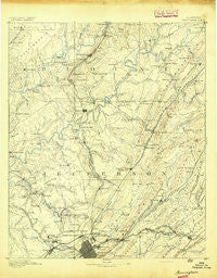
Birmingham, Alabama, USGS topographic map dated 1892.
Includes geographic coordinates (latitude and longitude). This topographic map is suitable for hiking, camping, and exploring, or framing it as a wall map.
Printed on-demand using high resolution imagery, on heavy weight and acid free paper, or alternatively on a variety of synthetic materials.
Topos available on paper, Waterproof, Poly, or Tyvek. Usually shipping rolled, unless combined with other folded maps in one order.
- Product Number: USGS-5542683
- Free digital map download (high-resolution, GeoPDF): Birmingham, Alabama (file size: 7 MB)
- Map Size: please refer to the dimensions of the GeoPDF map above
- Weight (paper map): ca. 55 grams
- Map Type: POD USGS Topographic Map
- Map Series: HTMC
- Map Verison: Historical
- Cell ID: 65005
- Scan ID: 305809
- Survey Year: 1887
- Datum: Unstated
- Map Projection: Unstated
- Map published by United States Geological Survey
- Map Language: English
- Scanner Resolution: 600 dpi
- Map Cell Name: Birmingham
- Grid size: 30 X 30 Minute
- Date on map: 1892
- Map Scale: 1:125000
- Geographical region: Alabama, United States
Neighboring Maps:
All neighboring USGS topo maps are available for sale online at a variety of scales.
Spatial coverage:
Topo map Birmingham, Alabama, covers the geographical area associated the following places:
- Compton - Mount Olive - Edgewater - Rock Ridge - Holiday Gardens - Sueann - Lake Highlands - Whites Chapel - Hampton Place - Ayres Estates - Valley Crest Estates - Coaldale - Frances Heights - Crockard Junction - Dogtown - Graysville Heights - Autumn Chase - Sherman Heights - Centercrest - Northgate Trailer Park - Elyton - Huffman - Ayres - Exum - Fieldstown - Kimberly - Hayes Highland - Balle Mobile Home Park - Norris Junction - Red Wine - Candlewood Lakes - Brookside - Roper - Plain View - Five Points South - Owenton - Morris - Rosa - Vanns - Forest Hills - Marks Village - Roebuck Springs - Bryan Estates - Roebuck - Innsbrooke - Von Dale - Harkness Crossroads - North Lake Park - Lovick - Crestview Hills - Chalkville - Bangor - Eastwood - Creel - Jefferson Park - Grays Gardens - Merrywood - Masseyline - Thomas - Oakville - Lakewood - Trussville Manor - Brookhurst - Trafford - Little Warrior - Daisey City - Springville Lake Estates - Hayden - Cardiff - Killough Springs - Old Leeds Forest - Selfville - Arkadelphia - Franklin Gardens - McCombs - Maplewood - Gate City - Berkley Hills - Pinson - Pine Knoll Vista - Fairview - Roebuck Plaza - Zion Heights - Thermal (historical) - Brents Cross Roads - Daisey City Trailer Park - Graymont - Eastwood Mobile Home Plaza - Forestdale - Cleveland - Baltimore (historical) - Lola City - Bridlewood Forest Estates - Near Acres Estates - Airport Highlands - Crocker Junction - Crosston - Gardendale - Irondale - Minor
- Map Area ID: AREA3433.5-87-86.5
- Northwest corner Lat/Long code: USGSNW34-87
- Northeast corner Lat/Long code: USGSNE34-86.5
- Southwest corner Lat/Long code: USGSSW33.5-87
- Southeast corner Lat/Long code: USGSSE33.5-86.5
- Northern map edge Latitude: 34
- Southern map edge Latitude: 33.5
- Western map edge Longitude: -87
- Eastern map edge Longitude: -86.5


