
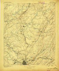
~ Birmingham AL topo map, 1:125000 scale, 30 X 30 Minute, Historical, 1895
Birmingham, Alabama, USGS topographic map dated 1895.
Includes geographic coordinates (latitude and longitude). This topographic map is suitable for hiking, camping, and exploring, or framing it as a wall map.
Printed on-demand using high resolution imagery, on heavy weight and acid free paper, or alternatively on a variety of synthetic materials.
Topos available on paper, Waterproof, Poly, or Tyvek. Usually shipping rolled, unless combined with other folded maps in one order.
- Product Number: USGS-5542681
- Free digital map download (high-resolution, GeoPDF): Birmingham, Alabama (file size: 8 MB)
- Map Size: please refer to the dimensions of the GeoPDF map above
- Weight (paper map): ca. 55 grams
- Map Type: POD USGS Topographic Map
- Map Series: HTMC
- Map Verison: Historical
- Cell ID: 65005
- Scan ID: 305808
- Survey Year: 1887
- Datum: Unstated
- Map Projection: Unstated
- Map published by United States Geological Survey
- Map Language: English
- Scanner Resolution: 600 dpi
- Map Cell Name: Birmingham
- Grid size: 30 X 30 Minute
- Date on map: 1895
- Map Scale: 1:125000
- Geographical region: Alabama, United States
Neighboring Maps:
All neighboring USGS topo maps are available for sale online at a variety of scales.
Spatial coverage:
Topo map Birmingham, Alabama, covers the geographical area associated the following places:
- Balle Mobile Home Park - Rosa - Danville - East Trussville (historical) - Roddams Trailer Park - Chetopa - Airport Highlands - Heathermoor Estates - Saddlewood - Edgewater - Pine Mountain - Oak Crossing - Crockard Junction - Douglasville - Baltimore (historical) - Ayres - Coalburg - Cedar Grove (historical) - Braggsville - Kingston - Cleveland - Oak Park - Forest Park - Seloca - Penfield Heights - Springdale - Shadywood - Avon Park - Dale (historical) - Magnolia Heights - Redmont Park - Bryan Estates - New Castle - Compton - Maplewood - Gurley - Fultondale - Hampton Place - Union Grove - Plaza Mobile Home Park - Ayres Estates - Five Points South - Fountain Heights - Cherokee Estates - Sherman Heights - West Ridge - Armstead - Daisey City - Meadowview Estates - Huffman - Red Wine - East Birmingham - Bridlewood Forest Estates - Echo Hills - Ketona - The Colony - Graystone - Brookmont - Watson - Ridgewood - Monmouth - Bendale - Oakville - Creel - Biscayne Highlands - Woodland Village - Kingsway Terrace - Roper - Holiday Park Estates - Longview Estates - Vulcan City - Graysville Heights - Chalkville - Brookside - Hunters Hill - Daisey City Trailer Park - Littleton - Magnolia Courts - Marks Village - Ruffner - Blount Springs - Wahouma - Moss Rock - Edgewater Junction - Hayden - Parsons - North Birmingham - Ridgewood Estates - Harkness Crossroads - Frenchtown - Pinson - Crosston - Weems - Ensley Highlands - Sandusky - Overbrook Estates - Crestline Gardens - Trussville - Fulton Springs - Trotwood Park
- Map Area ID: AREA3433.5-87-86.5
- Northwest corner Lat/Long code: USGSNW34-87
- Northeast corner Lat/Long code: USGSNE34-86.5
- Southwest corner Lat/Long code: USGSSW33.5-87
- Southeast corner Lat/Long code: USGSSE33.5-86.5
- Northern map edge Latitude: 34
- Southern map edge Latitude: 33.5
- Western map edge Longitude: -87
- Eastern map edge Longitude: -86.5


