
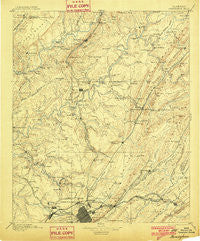
~ Birmingham AL topo map, 1:125000 scale, 30 X 30 Minute, Historical, 1895, updated 1901
Birmingham, Alabama, USGS topographic map dated 1895.
Includes geographic coordinates (latitude and longitude). This topographic map is suitable for hiking, camping, and exploring, or framing it as a wall map.
Printed on-demand using high resolution imagery, on heavy weight and acid free paper, or alternatively on a variety of synthetic materials.
Topos available on paper, Waterproof, Poly, or Tyvek. Usually shipping rolled, unless combined with other folded maps in one order.
- Product Number: USGS-5542675
- Free digital map download (high-resolution, GeoPDF): Birmingham, Alabama (file size: 8 MB)
- Map Size: please refer to the dimensions of the GeoPDF map above
- Weight (paper map): ca. 55 grams
- Map Type: POD USGS Topographic Map
- Map Series: HTMC
- Map Verison: Historical
- Cell ID: 65005
- Scan ID: 305501
- Imprint Year: 1901
- Survey Year: 1887
- Datum: Unstated
- Map Projection: Unstated
- Map published by United States Geological Survey
- Map Language: English
- Scanner Resolution: 600 dpi
- Map Cell Name: Birmingham
- Grid size: 30 X 30 Minute
- Date on map: 1895
- Map Scale: 1:125000
- Geographical region: Alabama, United States
Neighboring Maps:
All neighboring USGS topo maps are available for sale online at a variety of scales.
Spatial coverage:
Topo map Birmingham, Alabama, covers the geographical area associated the following places:
- Euclid Estates - Red Hill - Danzler - Forestdale Mobile Home Park - Brentwood - Cherokee Bend - Creel - Linton - Graysville - Larkwood - East Haven - Woodland Village - Alton - Baltimore (historical) - Oak Crossing - Nyota - County Line - Cahaba Cove - Bryan Estates - Lehigh - Queenstown - Glendale - Jet - New Castle - Morris - Pineview - Sunnyside - Locust Fork - Chetopa - Bendale - Cedar Grove (historical) - Selfville - Fairfield - York Mountain - Lovick - Alden - Adamsville - Oak Lawn - Fultondale Estates - Wahouma - Valley Crest Estates - Roddams Trailer Park - New Town - Bridlewood Forest Estates - McDonald Chapel - Trotwood Park - McCombs - Springdale - Ensley - Overbrook Estates - Gardendale - Clay - Seloca - Forest Hills - Cherokee Brook Estates - Centerwood Estates - Parker Hudson Estates - West Ensley - Blount Springs - South Highlands - Humoro - Saddlebrook - Docena - Sugar Creek - Candlewood Lakes - Blow Gourd - Roebuck Forest - Brookside - Coalburg - Sloan - Oakville - Sunset Mountain - Cahaba Crest - Saddlewood - Willow Grove Estates - Center Point - Dale (historical) - Blossburg - Ridgewood - Mulga - Whites Chapel - Sayreton - Edgewater - Woodaire Estates - Marks Village - Shadyside - Graysons Addition - Glasgow - Magnolia Courts - Pine Mountain - Carriage Hills - Inglenook - Killough Springs - East Lake - Robbins Crossroads - Scott City - Kingsway Terrace - Crumley Chapel - Morningside - Compton
- Map Area ID: AREA3433.5-87-86.5
- Northwest corner Lat/Long code: USGSNW34-87
- Northeast corner Lat/Long code: USGSNE34-86.5
- Southwest corner Lat/Long code: USGSSW33.5-87
- Southeast corner Lat/Long code: USGSSE33.5-86.5
- Northern map edge Latitude: 34
- Southern map edge Latitude: 33.5
- Western map edge Longitude: -87
- Eastern map edge Longitude: -86.5


