
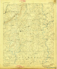
~ Ashland AL topo map, 1:125000 scale, 30 X 30 Minute, Historical, 1891, updated 1898
Ashland, Alabama, USGS topographic map dated 1891.
Includes geographic coordinates (latitude and longitude). This topographic map is suitable for hiking, camping, and exploring, or framing it as a wall map.
Printed on-demand using high resolution imagery, on heavy weight and acid free paper, or alternatively on a variety of synthetic materials.
Topos available on paper, Waterproof, Poly, or Tyvek. Usually shipping rolled, unless combined with other folded maps in one order.
- Product Number: USGS-5542669
- Free digital map download (high-resolution, GeoPDF): Ashland, Alabama (file size: 7 MB)
- Map Size: please refer to the dimensions of the GeoPDF map above
- Weight (paper map): ca. 55 grams
- Map Type: POD USGS Topographic Map
- Map Series: HTMC
- Map Verison: Historical
- Cell ID: 64919
- Scan ID: 305800
- Imprint Year: 1898
- Survey Year: 1889
- Datum: Unstated
- Map Projection: Unstated
- Map published by United States Geological Survey
- Map Language: English
- Scanner Resolution: 600 dpi
- Map Cell Name: Ashland
- Grid size: 30 X 30 Minute
- Date on map: 1891
- Map Scale: 1:125000
- Geographical region: Alabama, United States
Neighboring Maps:
All neighboring USGS topo maps are available for sale online at a variety of scales.
Spatial coverage:
Topo map Ashland, Alabama, covers the geographical area associated the following places:
- Liberty - Berwick - Goldville - Sikesville - Shiloh - Simpson - Needmore - Old Providence - Ashland - Malone - Concord - Delta - Foster Crossroad - Liberty - Micaville - Swagg - Corinth - Emuckfaw (historical) - Campbell Springs - Cragford - Mount Moriah - Ofelia - Louina - Center West - Abner (historical) - Cooley Crossroads - Christiana - Folsom - Cowpens - Shiloh - Gibsonville - Fuller Crossroad - New Providence - Gunthertown - Woolfolk - McElderry - High Pine - Wadley - Pyriton - Haynes Crossroad - Harkins Crossroads - Union Hill - Springhill - Weathers - Frog Eye - Campbells Crossroads - Almond - Bowden Grove - Hillabi (historical) - Abanda - Elder (historical) - Bluff Springs - Barfield - Forester Chapel - Perryville - Bethleham (historical) - Concord - Highland - Erin - Millerville - Ironaton - Lineville - Watts Crossroads - Bosworth - Corinth - Truett - Rays Crossroads - Dingler - Midway - Pine Tuckey - Motley - Cedron - Chinnabee - Harmony (historical) - New Site - Zana - Mellow Valley - Milner - Glades - Carr Mill - Cleveland Crossroads - Chandler Springs - Hopeful - Daviston - Pinkneyville - Zana (historical) - Blake - Hackneyville - Corinth - Clairmont Springs - Wildwood - Union
- Map Area ID: AREA33.533-86-85.5
- Northwest corner Lat/Long code: USGSNW33.5-86
- Northeast corner Lat/Long code: USGSNE33.5-85.5
- Southwest corner Lat/Long code: USGSSW33-86
- Southeast corner Lat/Long code: USGSSE33-85.5
- Northern map edge Latitude: 33.5
- Southern map edge Latitude: 33
- Western map edge Longitude: -86
- Eastern map edge Longitude: -85.5


