
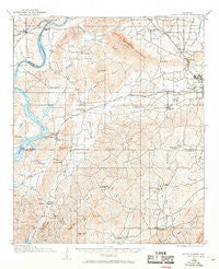
~ Gantts Quarry AL topo map, 1:62500 scale, 15 X 15 Minute, Historical, 1915, updated 1970
Gantts Quarry, Alabama, USGS topographic map dated 1915.
Includes geographic coordinates (latitude and longitude). This topographic map is suitable for hiking, camping, and exploring, or framing it as a wall map.
Printed on-demand using high resolution imagery, on heavy weight and acid free paper, or alternatively on a variety of synthetic materials.
Topos available on paper, Waterproof, Poly, or Tyvek. Usually shipping rolled, unless combined with other folded maps in one order.
- Product Number: USGS-5542313
- Free digital map download (high-resolution, GeoPDF): Gantts Quarry, Alabama (file size: 9 MB)
- Map Size: please refer to the dimensions of the GeoPDF map above
- Weight (paper map): ca. 55 grams
- Map Type: POD USGS Topographic Map
- Map Series: HTMC
- Map Verison: Historical
- Cell ID: 54465
- Scan ID: 305584
- Imprint Year: 1970
- Survey Year: 1915
- Datum: NAD27
- Map Projection: Polyconic
- Map published by United States Geological Survey
- Map Language: English
- Scanner Resolution: 600 dpi
- Map Cell Name: Gantts Quarry
- Grid size: 15 X 15 Minute
- Date on map: 1915
- Map Scale: 1:62500
- Geographical region: Alabama, United States
Neighboring Maps:
All neighboring USGS topo maps are available for sale online at a variety of scales.
Spatial coverage:
Topo map Gantts Quarry, Alabama, covers the geographical area associated the following places:
- Valentine - Blue Springs - Pleasant Hill - Indian Shoals - Strickland Crossroads - Walco - Comerdale - Kahatchee - Center Hill - Talladega Springs - Five Points - Zubers - Fayetteville - Deans - Mignon - Unity - Gantts Junction - Carleton Point - Oak Grove - Kowakas Mobile Home Park - Marble Valley - Sulphur Spring - Wilsonville - Paradise Point Estates - Mount Sharon - Gantts Quarry - Weogufka - Odena - Thomas Hill - Shelby Shores - Homestead - Sylacauga
- Map Area ID: AREA33.2533-86.5-86.25
- Northwest corner Lat/Long code: USGSNW33.25-86.5
- Northeast corner Lat/Long code: USGSNE33.25-86.25
- Southwest corner Lat/Long code: USGSSW33-86.5
- Southeast corner Lat/Long code: USGSSE33-86.25
- Northern map edge Latitude: 33.25
- Southern map edge Latitude: 33
- Western map edge Longitude: -86.5
- Eastern map edge Longitude: -86.25


