
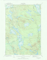
~ Nicatous Lake ME topo map, 1:62500 scale, 15 X 15 Minute, Historical, 1932, updated 1970
Nicatous Lake, Maine, USGS topographic map dated 1932.
Includes geographic coordinates (latitude and longitude). This topographic map is suitable for hiking, camping, and exploring, or framing it as a wall map.
Printed on-demand using high resolution imagery, on heavy weight and acid free paper, or alternatively on a variety of synthetic materials.
Topos available on paper, Waterproof, Poly, or Tyvek. Usually shipping rolled, unless combined with other folded maps in one order.
- Product Number: USGS-5536811
- Free digital map download (high-resolution, GeoPDF): Nicatous Lake, Maine (file size: 7 MB)
- Map Size: please refer to the dimensions of the GeoPDF map above
- Weight (paper map): ca. 55 grams
- Map Type: POD USGS Topographic Map
- Map Series: HTMC
- Map Verison: Historical
- Cell ID: 58430
- Scan ID: 306681
- Imprint Year: 1970
- Woodland Tint: Yes
- Survey Year: 1932
- Datum: Unstated
- Map Projection: Polyconic
- Map published by United States Geological Survey
- Map Language: English
- Scanner Resolution: 600 dpi
- Map Cell Name: Nicatous Lake
- Grid size: 15 X 15 Minute
- Date on map: 1932
- Map Scale: 1:62500
- Geographical region: Maine, United States
Neighboring Maps:
All neighboring USGS topo maps are available for sale online at a variety of scales.
Spatial coverage:
Topo map Nicatous Lake, Maine, covers the geographical area associated the following places:
- Oqiton Township - Gassabias Stream - Birch Island - Fifth Lake Mountain - Trueworthy Pond - West Lake Ridge - Lower Taylor Brook - Oxhead Stream - Crystal Pond - T41 MD BPP - Duck Mountain - T40 MD BPP - Perch Island - Chain Stream - Number Six Camp - Eagle Lake - Mace Brook - Drag Brook - Butterfield Island - Trout Pond - Fifth Lake Stream - Nicatous Lake Dam - Dollar Island - Middle Pistol Lake - Spencer Pond - Middle Oxhead Pond - Duck Lake - Upper Taylor Brook - Duck Lake Cove - Morrison Ridge - Spencer Brook - Coombs Brook - Gassabias Lake - Upper Chain Lake - Nicatous Club - Number Two Camp - Cold Spring Campground - Spring Lake - Burnt Land Lake - Maple Grove Campground - Horseshoe Cove - Middle Unknown Lake - Lower Chain Lake - Porter Cove - Knight Dam - Chain Island - Sand Island - Woodchopping Ridge - Porter Brook - Horseshoe Mountain - Cranberry Island - Pughole Pond - Lower Oxhead Pond - Selmore Pond - Little Guagus Stream - Partridge Brook - Sabao Mountain - T3 ND BPP - Eagle Brook - Dayton Island - Middle Chain Lake - Upper Unknown Lake - Moose Cove - Explorers Club - Little Pickerel Pond - Upper Pistol Lake - Lower Pistol Lake - Side Pistol Lake - Horseshoe Lake - Duck Lake Brook - Campbell Lake - Porter Pond - Poplar Tavern Camp - Abamgamook Lake - Bacon Island - Lower Unknown Lake - Pine Island - Green Lake - Nicatous Lake - West Lake - Eagle Lake Trail - Upper Sabao Lake - Otter Pond - Loon Pond
- Map Area ID: AREA45.2545-68.25-68
- Northwest corner Lat/Long code: USGSNW45.25-68.25
- Northeast corner Lat/Long code: USGSNE45.25-68
- Southwest corner Lat/Long code: USGSSW45-68.25
- Southeast corner Lat/Long code: USGSSE45-68
- Northern map edge Latitude: 45.25
- Southern map edge Latitude: 45
- Western map edge Longitude: -68.25
- Eastern map edge Longitude: -68


