
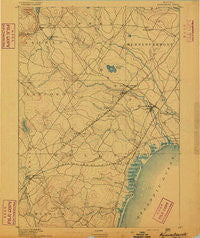
~ Kennebunk ME topo map, 1:62500 scale, 15 X 15 Minute, Historical, 1891
Kennebunk, Maine, USGS topographic map dated 1891.
Includes geographic coordinates (latitude and longitude). This topographic map is suitable for hiking, camping, and exploring, or framing it as a wall map.
Printed on-demand using high resolution imagery, on heavy weight and acid free paper, or alternatively on a variety of synthetic materials.
Topos available on paper, Waterproof, Poly, or Tyvek. Usually shipping rolled, unless combined with other folded maps in one order.
- Product Number: USGS-5536645
- Free digital map download (high-resolution, GeoPDF): Kennebunk, Maine (file size: 4 MB)
- Map Size: please refer to the dimensions of the GeoPDF map above
- Weight (paper map): ca. 55 grams
- Map Type: POD USGS Topographic Map
- Map Series: HTMC
- Map Verison: Historical
- Cell ID: 56093
- Scan ID: 807537
- Survey Year: 1889
- Datum: Unstated
- Map Projection: Unstated
- Map published by United States Geological Survey
- Map Language: English
- Scanner Resolution: 508 dpi
- Map Cell Name: Kennebunk
- Grid size: 15 X 15 Minute
- Date on map: 1891
- Map Scale: 1:62500
- Geographical region: Maine, United States
Neighboring Maps:
All neighboring USGS topo maps are available for sale online at a variety of scales.
Spatial coverage:
Topo map Kennebunk, Maine, covers the geographical area associated the following places:
- Kennebunk Beach - Tatnic - Alfred Mills - Wells Beach Station - Varney Crossing - Bald Hill Crossing - Parsonage Corner - Lower Landing - Perkins Town - Hobbs Crossing - Upper Landing - West Kennebunk - Kennebunk Landing - South Sanford - Bartlett Mills - Wells - Wells Branch - Moody - Spang Mills - Kennebunk - Blueberry Ridge Trailer Park - Highpine - Buffum Hill - Grays Corner - Wells Beach - Moody Point - Cozy Corners - Alfred - Boyd Corner - Drakes Island - North Berwick - Four Corners - Elms - Moody Beach - Charles Chase Corner - Alewife - Saywards Corner - Days Mill
- Map Area ID: AREA43.543.25-70.75-70.5
- Northwest corner Lat/Long code: USGSNW43.5-70.75
- Northeast corner Lat/Long code: USGSNE43.5-70.5
- Southwest corner Lat/Long code: USGSSW43.25-70.75
- Southeast corner Lat/Long code: USGSSE43.25-70.5
- Northern map edge Latitude: 43.5
- Southern map edge Latitude: 43.25
- Western map edge Longitude: -70.75
- Eastern map edge Longitude: -70.5


