
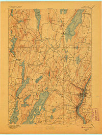
~ Augusta ME topo map, 1:62500 scale, 15 X 15 Minute, Historical, 1892, updated 1906
Augusta, Maine, USGS topographic map dated 1892.
Includes geographic coordinates (latitude and longitude). This topographic map is suitable for hiking, camping, and exploring, or framing it as a wall map.
Printed on-demand using high resolution imagery, on heavy weight and acid free paper, or alternatively on a variety of synthetic materials.
Topos available on paper, Waterproof, Poly, or Tyvek. Usually shipping rolled, unless combined with other folded maps in one order.
- Product Number: USGS-5536041
- Free digital map download (high-resolution, GeoPDF): Augusta, Maine (file size: 6 MB)
- Map Size: please refer to the dimensions of the GeoPDF map above
- Weight (paper map): ca. 55 grams
- Map Type: POD USGS Topographic Map
- Map Series: HTMC
- Map Verison: Historical
- Cell ID: 50794
- Scan ID: 807351
- Imprint Year: 1906
- Survey Year: 1890
- Datum: Unstated
- Map Projection: Unstated
- Map published by United States Geological Survey
- Map Language: English
- Scanner Resolution: 508 dpi
- Map Cell Name: Augusta
- Grid size: 15 X 15 Minute
- Date on map: 1892
- Map Scale: 1:62500
- Geographical region: Maine, United States
Neighboring Maps:
All neighboring USGS topo maps are available for sale online at a variety of scales.
Spatial coverage:
Topo map Augusta, Maine, covers the geographical area associated the following places:
- Locks Corner - Summerhaven - Bangs Beach - Winthrop Center - North Augusta - Wings Mills - Granite Hill - Hallowell - Readfield Depot - West Sidney - Belgrade - Island Park - Readfield - Maranacook - East Winthrop - Augusta - Manchester - Winthrop - Sturtevant Hill - Pelton Hill - Bacons Corner - Dunns Corners - Tallwood
- Map Area ID: AREA44.544.25-70-69.75
- Northwest corner Lat/Long code: USGSNW44.5-70
- Northeast corner Lat/Long code: USGSNE44.5-69.75
- Southwest corner Lat/Long code: USGSSW44.25-70
- Southeast corner Lat/Long code: USGSSE44.25-69.75
- Northern map edge Latitude: 44.5
- Southern map edge Latitude: 44.25
- Western map edge Longitude: -70
- Eastern map edge Longitude: -69.75


