
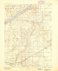
~ Des Plaines IL topo map, 1:62500 scale, 15 X 15 Minute, Historical, 1890
Des Plaines, Illinois, USGS topographic map dated 1890.
Includes geographic coordinates (latitude and longitude). This topographic map is suitable for hiking, camping, and exploring, or framing it as a wall map.
Printed on-demand using high resolution imagery, on heavy weight and acid free paper, or alternatively on a variety of synthetic materials.
Topos available on paper, Waterproof, Poly, or Tyvek. Usually shipping rolled, unless combined with other folded maps in one order.
- Product Number: USGS-5531539
- Free digital map download (high-resolution, GeoPDF): Des Plaines, Illinois (file size: 7 MB)
- Map Size: please refer to the dimensions of the GeoPDF map above
- Weight (paper map): ca. 55 grams
- Map Type: POD USGS Topographic Map
- Map Series: HTMC
- Map Verison: Historical
- Cell ID: 53375
- Scan ID: 309389
- Survey Year: 1890
- Datum: Unstated
- Map Projection: Unstated
- Map published by United States Geological Survey
- Map Language: English
- Scanner Resolution: 600 dpi
- Map Cell Name: Des Plaines
- Grid size: 15 X 15 Minute
- Date on map: 1890
- Map Scale: 1:62500
- Geographical region: Illinois, United States
Neighboring Maps:
All neighboring USGS topo maps are available for sale online at a variety of scales.
Spatial coverage:
Topo map Des Plaines, Illinois, covers the geographical area associated the following places:
- Cedar Acres - Stately Acres - Ruffled Feathers Golf Community - Chickasaw - Spaniel Woods - Long Run Acres - Anand Brook - Hickory Hills - Doctor Parker Place - Sylvan Hills - Tedens (historical) - Somerset Hills - Hastings - Maple Leaf Estates - Oak Lawn - Mallard Lake Estates - Gombis - Burr Ridge - Colonial Acres - Twin Lakes - Hidden Valley - Pheasant Hollow S - Crystal Lake Estates - Deboer Woods - Equestrian Woods - Steele - Coventry Heights - Saddle Brook Run - Pine Hills Estates - Wilco Estates - Willow Springs - Bellbrook - Gilletts - Golden Oak Estates - Cinnamon Creek - New Lenox - Meadowview - Pineview Hills - Foxley Acres - Spring Creek Woods - Palisades - Farm View Hills - Rolling Glen - Windmill Estates - Fernway Park - Pebble Creek - Burbank - Palos Hills - Pheasant Hollow N - Oak Valley - Spring View West - Erin Hills - Goodings Grove - Chicago Ridge - Goeselville - Stadler Ridge Estates - Spring Lake Woods - Fox Chase Estates - Lincolnwood Hills - Sylvan Woods - Creekwood - Orland Hills - Equestrian Estates - Crestwood - Kingstone Hills - Wedgewood Heights - Woodbine - Old Oaks Estates - Heritage Estates - King Acres - Dawn Wood - Derby Hills - Arrow Ridge Mobile Home Park - Kensington - Orland Park - Spring Creek - Cedar Glen - Palos Park - Arbury Hills - Derby Meadows - Frankfort Square - Lincoln Estates - Marley - Homer Glen - Hadley - Fernway - Long Run Creek - Twin Creek - Country Squire - Hillside Court - Bristol Heights - Worth - Southmoor - Tinley Park - Palos Heights - Pavinita - Moorefield Estates - Mokena - Alpine - Fox Hills
- Map Area ID: AREA41.7541.5-88-87.75
- Northwest corner Lat/Long code: USGSNW41.75-88
- Northeast corner Lat/Long code: USGSNE41.75-87.75
- Southwest corner Lat/Long code: USGSSW41.5-88
- Southeast corner Lat/Long code: USGSSE41.5-87.75
- Northern map edge Latitude: 41.75
- Southern map edge Latitude: 41.5
- Western map edge Longitude: -88
- Eastern map edge Longitude: -87.75


