
~ Alturas CA topo map, 1:250000 scale, 1 X 2 Degree, Historical, 1962, updated 1962
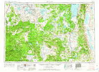
Alturas, California, USGS topographic map dated 1962.
Includes geographic coordinates (latitude and longitude). This topographic map is suitable for hiking, camping, and exploring, or framing it as a wall map.
Printed on-demand using high resolution imagery, on heavy weight and acid free paper, or alternatively on a variety of synthetic materials.
Topos available on paper, Waterproof, Poly, or Tyvek. Usually shipping rolled, unless combined with other folded maps in one order.
- Product Number: USGS-5506481
- Free digital map download (high-resolution, GeoPDF): Alturas, California (file size: 19 MB)
- Map Size: please refer to the dimensions of the GeoPDF map above
- Weight (paper map): ca. 55 grams
- Map Type: POD USGS Topographic Map
- Map Series: HTMC
- Map Verison: Historical
- Cell ID: 75011
- Scan ID: 299719
- Imprint Year: 1962
- Woodland Tint: Yes
- Aerial Photo Year: 1954
- Edit Year: 1962
- Datum: Unstated
- Map Projection: Transverse Mercator
- Map published by United States Army Corps of Engineers
- Map published by United States Army
- Map Language: English
- Scanner Resolution: 600 dpi
- Map Cell Name: Alturas
- Grid size: 1 X 2 Degree
- Date on map: 1962
- Map Scale: 1:250000
- Geographical region: California, United States
Neighboring Maps:
All neighboring USGS topo maps are available for sale online at a variety of scales.
Spatial coverage:
Topo map Alturas, California, covers the geographical area associated the following places:
- K Flourney - Derner - Bormister - Hot Springs - Sage Hen - Meares - Grizzlie Place - Ramsey - Curtis - White Horse - California Pines - Cayton - D Flourney - Avila Place - Day - Kephart - Evans Place - Bieber - Ambrose - Homestead - McArthur - Bayley (historical) - Juniper - Copic - Dalton - Hannchen - Pittville - Cedarville - R Flourney - Fairport - Liskey - Dorris - Madeline - Fleener Place - Nubieber - Big Bend - McArthur - Alturas - Adin - Canby - Bray - New Pine Creek - Paola (historical) - Harper - Kegg - Glenburn - Tionesta - Cornell - Brooks Mill - Spalding Corner - McGarva - Fort Bidwell - Hambone - Scotty Place - Davis Creek - Tulelake - Kalina - Obie - Fletcher (historical) - Pumpkin Center - Daphnedale Park - Lake City - Tuber - Dibble Place - Suty (historical) - Kandra - Kauffman - Slagger - Old Hulbert Place - Fletcher Place - Laird Landing - Lookout - Canby Cross - Newell - Boles - Gomez - Willow Ranch - Vestil - Dan Ryan Place - Bartle - Pondosa - Campbell - Scarface - Lookout Junction - Harlow Place - Kinyon - Lakeview Junction - Hatfield - Eagleville - Tennant - New Pine Creek - Demuth - Fall River Mills - Surprise Station - Mulkey Place - Somerset - Ash Creek Station (historical) - Menlo Baths - Pinnio - Williams
- Map Area ID: AREA4241-122-120
- Northwest corner Lat/Long code: USGSNW42-122
- Northeast corner Lat/Long code: USGSNE42-120
- Southwest corner Lat/Long code: USGSSW41-122
- Southeast corner Lat/Long code: USGSSE41-120
- Northern map edge Latitude: 42
- Southern map edge Latitude: 41
- Western map edge Longitude: -122
- Eastern map edge Longitude: -120


