
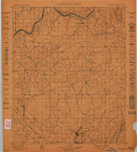
~ Coalgate OK topo map, 1:125000 scale, 30 X 30 Minute, Historical, 1899
Coalgate, Oklahoma, USGS topographic map dated 1899.
Includes geographic coordinates (latitude and longitude). This topographic map is suitable for hiking, camping, and exploring, or framing it as a wall map.
Printed on-demand using high resolution imagery, on heavy weight and acid free paper, or alternatively on a variety of synthetic materials.
Topos available on paper, Waterproof, Poly, or Tyvek. Usually shipping rolled, unless combined with other folded maps in one order.
- Product Number: USGS-5472905
- Free digital map download (high-resolution, GeoPDF): Coalgate, Oklahoma (file size: 5 MB)
- Map Size: please refer to the dimensions of the GeoPDF map above
- Weight (paper map): ca. 55 grams
- Map Type: POD USGS Topographic Map
- Map Series: HTMC
- Map Verison: Historical
- Cell ID: 65228
- Scan ID: 802509
- Survey Year: 1896
- Datum: Unstated
- Map Projection: Unstated
- Map published by United States Geological Survey
- Map Language: English
- Scanner Resolution: 508 dpi
- Map Cell Name: Coalgate
- Grid size: 30 X 30 Minute
- Date on map: 1899
- Map Scale: 1:125000
- Geographical region: Oklahoma, United States
Neighboring Maps:
All neighboring USGS topo maps are available for sale online at a variety of scales.
Spatial coverage:
Topo map Coalgate, Oklahoma, covers the geographical area associated the following places:
- Leader - Centrahoma - Cottonwood - Coalgate - Calvin - Parker - Wardville - Stuart - Lula - Phillips - Ward Springs - Flora - Steedman - Ashland - Cairo - Rock Creek - Tupelo - Gerty - Cabaniss - Allen - Atwood - Citra - Jaydee - Non
- Map Area ID: AREA3534.5-96.5-96
- Northwest corner Lat/Long code: USGSNW35-96.5
- Northeast corner Lat/Long code: USGSNE35-96
- Southwest corner Lat/Long code: USGSSW34.5-96.5
- Southeast corner Lat/Long code: USGSSE34.5-96
- Northern map edge Latitude: 35
- Southern map edge Latitude: 34.5
- Western map edge Longitude: -96.5
- Eastern map edge Longitude: -96


