
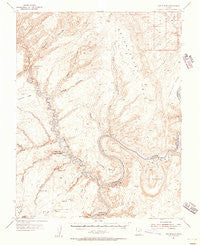
~ The Rincon UT topo map, 1:62500 scale, 15 X 15 Minute, Historical, 1953, updated 1956
The Rincon, Utah, USGS topographic map dated 1953.
Includes geographic coordinates (latitude and longitude). This topographic map is suitable for hiking, camping, and exploring, or framing it as a wall map.
Printed on-demand using high resolution imagery, on heavy weight and acid free paper, or alternatively on a variety of synthetic materials.
Topos available on paper, Waterproof, Poly, or Tyvek. Usually shipping rolled, unless combined with other folded maps in one order.
- Product Number: USGS-5462961
- Free digital map download (high-resolution, GeoPDF): The Rincon, Utah (file size: 8 MB)
- Map Size: please refer to the dimensions of the GeoPDF map above
- Weight (paper map): ca. 55 grams
- Map Type: POD USGS Topographic Map
- Map Series: HTMC
- Map Verison: Historical
- Cell ID: 63504
- Scan ID: 252352
- Imprint Year: 1956
- Aerial Photo Year: 1951
- Field Check Year: 1953
- Datum: NAD27
- Map Projection: Polyconic
- Map published by United States Geological Survey
- Map Language: English
- Scanner Resolution: 600 dpi
- Map Cell Name: The Rincon
- Grid size: 15 X 15 Minute
- Date on map: 1953
- Map Scale: 1:62500
- Geographical region: Utah, United States
Neighboring Maps:
All neighboring USGS topo maps are available for sale online at a variety of scales.
Spatial coverage:
Topo map The Rincon, Utah, covers the geographical area associated the following places:
- Chaffin Cabin (historical) - The Rincon - Indian Creek - Stevens Arch - Cow Canyon - Miners Stairs - Bell Tower Window - Stevens Canyon - Iceberg Canyon - Long Canyon - Triple Arch - Davis Gulch - Clear Creek - Flying Eagle Cove - The Slope - Explorer Canyon - Gregory Natural Bridge (historical) - Hole-in-the-Rock - Fortymile Gulch - Cathedral in the Desert - Willow Creek - Hole-in-the-Rock Crossing - Pollywog Bench - Bement Arch - Hole-in-the-Rock Historical Marker - Aleson Arch - Poor Mans Placer (historical) - Navajo Creek - Fortymile Creek - Bowns Canyon - LaGorce Arch - Ribbon Canyon - Escalante River - Fence Canyon - Willow Gulch - Lake Powell - Jackass Bench (historical) - Little Anna Bar (historical) - Zane Grey Arch - Bennetts Oil Field - Oil Seep Bar (historical) - Wilson Mesa - Fiftymile Creek - Coyote Gulch
- Map Area ID: AREA37.537.25-111-110.75
- Northwest corner Lat/Long code: USGSNW37.5-111
- Northeast corner Lat/Long code: USGSNE37.5-110.75
- Southwest corner Lat/Long code: USGSSW37.25-111
- Southeast corner Lat/Long code: USGSSE37.25-110.75
- Northern map edge Latitude: 37.5
- Southern map edge Latitude: 37.25
- Western map edge Longitude: -111
- Eastern map edge Longitude: -110.75


