
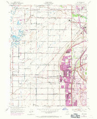
~ Roy UT topo map, 1:24000 scale, 7.5 X 7.5 Minute, Historical, 1955, updated 1971
Roy, Utah, USGS topographic map dated 1955.
Includes geographic coordinates (latitude and longitude). This topographic map is suitable for hiking, camping, and exploring, or framing it as a wall map.
Printed on-demand using high resolution imagery, on heavy weight and acid free paper, or alternatively on a variety of synthetic materials.
Topos available on paper, Waterproof, Poly, or Tyvek. Usually shipping rolled, unless combined with other folded maps in one order.
- Product Number: USGS-5460421
- Free digital map download (high-resolution, GeoPDF): Roy, Utah (file size: 11 MB)
- Map Size: please refer to the dimensions of the GeoPDF map above
- Weight (paper map): ca. 55 grams
- Map Type: POD USGS Topographic Map
- Map Series: HTMC
- Map Verison: Historical
- Cell ID: 38825
- Scan ID: 251592
- Imprint Year: 1971
- Woodland Tint: Yes
- Photo Revision Year: 1969
- Aerial Photo Year: 1969
- Survey Year: 1955
- Datum: NAD27
- Map Projection: Polyconic
- Map published by United States Geological Survey
- Map published by United States Army Corps of Engineers
- Map Language: English
- Scanner Resolution: 600 dpi
- Map Cell Name: Roy
- Grid size: 7.5 X 7.5 Minute
- Date on map: 1955
- Map Scale: 1:24000
- Geographical region: Utah, United States
Neighboring Maps:
All neighboring USGS topo maps are available for sale online at a variety of scales.
Spatial coverage:
Topo map Roy, Utah, covers the geographical area associated the following places:
- Snap-N-Fox Farms - Sun Ray - Cedar Ridge - Meadowlane - Lewis Estates - Carriage Lane Number Two - Rayneer - Golden West Villa - Linda Vista - Foxglen - Rich Acres - Lucin - Quail Point - Donita - Sherwood Oaks Condominium - Colonial Plaza Condominium - Willow Wood - Swan Creek Estates - Lemans - Lazy L Estates - Apple Park - Elta Glen - Heather Heights - Muir Meadows - Barton-Thompson - Roy Park Addition - Harveys Redwood Estates - Valley View Acres - West Hills - Shannondoah Estates - Great Basin Addition - William R Patterson - Tubbs - Fuit - Villa Moritz - Westlake Village - Park Lake - Westridge - Kentwood Estates - New Hampton Manor - Valley Park Estates - Anderson West Acres - Purser - Coy - Barton - Laurel Lea - Sunrise Park - Arsenal Villa - Shamrock - Eves Garden - Herefordshire Condominium - Loma Bonita - Hill Acres - Northpoint Condominium - Sunset - Al Vi Village - Rosewood Manor Condominium - Allred - Gilene - Vern G Taylor - Bay View Park - Westbrook - Peppermint Park - Kanesville - Morby Park - Deanetta - Town and Country Estates - Hal-Vern Park Addition - Valley Green Estates - Jones - DeGiorgio - Colonial Gardens Condominium - Tanner - Marianne Condominium - Harmony Park - Fawcett - Lawndale Addition - Fairway Estates - Carriage Place - Maybrook - Clinton - Suburban Heights - Country Lane - Par Four - Alpine Ranchettes - Commonwealth Square Condominium - John Fuit - Kelley Kay Acres - Hy-Mesa - Jill - Lakeside Park - Apple Estates - Linda Vista - Terry Estates - Enchanted Homes Addition - Pheasant Run Estates - Sandridge Estates - Goodfellow - Scotts Dale - He Flys
- Map Area ID: AREA41.2541.125-112.125-112
- Northwest corner Lat/Long code: USGSNW41.25-112.125
- Northeast corner Lat/Long code: USGSNE41.25-112
- Southwest corner Lat/Long code: USGSSW41.125-112.125
- Southeast corner Lat/Long code: USGSSE41.125-112
- Northern map edge Latitude: 41.25
- Southern map edge Latitude: 41.125
- Western map edge Longitude: -112.125
- Eastern map edge Longitude: -112


