
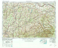
~ Binghamton NY topo map, 1:250000 scale, 1 X 2 Degree, Historical, 1948, updated 1980
Binghamton, New York, USGS topographic map dated 1948.
Includes geographic coordinates (latitude and longitude). This topographic map is suitable for hiking, camping, and exploring, or framing it as a wall map.
Printed on-demand using high resolution imagery, on heavy weight and acid free paper, or alternatively on a variety of synthetic materials.
Topos available on paper, Waterproof, Poly, or Tyvek. Usually shipping rolled, unless combined with other folded maps in one order.
- Product Number: USGS-5454813
- Free digital map download (high-resolution, GeoPDF): Binghamton, New York (file size: 20 MB)
- Map Size: please refer to the dimensions of the GeoPDF map above
- Weight (paper map): ca. 55 grams
- Map Type: POD USGS Topographic Map
- Map Series: HTMC
- Map Verison: Historical
- Cell ID: 68676
- Scan ID: 123303
- Imprint Year: 1980
- Woodland Tint: Yes
- Visual Version Number: 1
- Aerial Photo Year: 1944
- Datum: NAD27
- Map Projection: Transverse Mercator
- Map published by United States Geological Survey
- Map Language: English
- Scanner Resolution: 600 dpi
- Map Cell Name: Binghamton
- Grid size: 1 X 2 Degree
- Date on map: 1948
- Map Scale: 1:250000
- Geographical region: New York, United States
Neighboring Maps:
All neighboring USGS topo maps are available for sale online at a variety of scales.
Spatial coverage:
Topo map Binghamton, New York, covers the geographical area associated the following places:
- Church Corners - Fort Hunter - Kingdom - Hardscrabble - Button City - West Laurens - Halcott Center - South Edmeston - South Berne - Downsville - Franklin Depot - Lexington - West Brookfield - Westover - Colliersville - Cattown - Grand Gorge - Keeney - Munns - Richfield Springs - Blackesley Corner - East Freetown - Loomis - Hillcrest Mobile Home Park - North Columbia - Creekside Village - Sharon Center - Jones Crossing - Charlotteville - Jewett Center - Middle Bridge - Lost Valley - Edge of Town Mobile Home Park - North Bridgewater - Pinewoods Mobile Home Park - Hamilton - Five Corners - Bovina - South Gilboa Station - Sheds - Mount Upton - Amblerville - Taylor - Pharsalia - Gulf Summit - Cook Corners - Owlsville - Jefferson - Yaleville - Hamilton Center - Kortright Center - Polkville - Moscow Hill - Maplecrest - Bettsburg - Westford - Morrisville Station - Glenford - Charlesworth Corners - Hubbardsville - Lentsville - Birmingham Corners - Earlville - Arabia - East Pharsalia - Green Corners - Lower Cincinnatus - Maple Grove - Tuscan - Guideboard - Tunnel - Signal Mobile Home Park - Hartwick - North Lexington - West Windsor - Reidsville - Chase - Mosquito Point - Erieville - Sidney Center - Oneida Village Mobile Home Park - East Delhi - Haynes - Leisure Village Mobile Home Park - Otselic - Burlington - Hallsville - Kerryville - Trout Creek - Conklin - Boiceville - Berryville - Arkville - Forge Hollow - Pratts - Hinmans Corners - Chenango Forks - Pleasant Brook - Longyear (historical) - Franklin
- Map Area ID: AREA4342-76-74
- Northwest corner Lat/Long code: USGSNW43-76
- Northeast corner Lat/Long code: USGSNE43-74
- Southwest corner Lat/Long code: USGSSW42-76
- Southeast corner Lat/Long code: USGSSE42-74
- Northern map edge Latitude: 43
- Southern map edge Latitude: 42
- Western map edge Longitude: -76
- Eastern map edge Longitude: -74


