
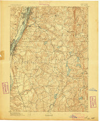
~ Troy NY topo map, 1:62500 scale, 15 X 15 Minute, Historical, 1893
Troy, New York, USGS topographic map dated 1893.
Includes geographic coordinates (latitude and longitude). This topographic map is suitable for hiking, camping, and exploring, or framing it as a wall map.
Printed on-demand using high resolution imagery, on heavy weight and acid free paper, or alternatively on a variety of synthetic materials.
Topos available on paper, Waterproof, Poly, or Tyvek. Usually shipping rolled, unless combined with other folded maps in one order.
- Product Number: USGS-5454205
- Free digital map download (high-resolution, GeoPDF): Troy, New York (file size: 8 MB)
- Map Size: please refer to the dimensions of the GeoPDF map above
- Weight (paper map): ca. 55 grams
- Map Type: POD USGS Topographic Map
- Map Series: HTMC
- Map Verison: Historical
- Cell ID: 63716
- Scan ID: 144351
- Visual Version Number: 1
- Survey Year: 1891
- Datum: Unstated
- Map Projection: Unstated
- Map published by United States Geological Survey
- Map Language: English
- Scanner Resolution: 600 dpi
- Map Cell Name: Troy
- Grid size: 15 X 15 Minute
- Date on map: 1893
- Map Scale: 1:62500
- Geographical region: New York, United States
Neighboring Maps:
All neighboring USGS topo maps are available for sale online at a variety of scales.
Spatial coverage:
Topo map Troy, New York, covers the geographical area associated the following places:
- Sherwood Park - Green Island - Hampton Park - Luther - Defreestville - Albia - Van Allen Park - Eagle Mills - Rivers Mobile Home Park - Creekside Mobile Home Park - Sycaway - Couse - Hoag Corners - Millers Corners - Menands - Rosemont Park - Clinton Heights - Rainbow Mobile Home Park - Yarbrough Homes - East Nassau - Glass Lake - Watervliet - Brookview - Clinton Park - Braeside - Prospect Heights - Stony Point - North Nassau - Eastmor - East Schodack - Rosecrans Park - Morey Park - Pine Haven Motor Home Park - West Sand Lake - Averill Park - South Troy - Brunswick - Denault Corners - Maple Grove - Snyders Corner - South Schodack - Wynantskill - Schodack Center - Barberville - Mountain View - Troy - Rensselaer - East Greenbush - Bon Acre - Poestenkill - Nassau - North Schodack - Sand Lake - Hampton Manor - Ives Corner - Best - Cedar Acres Mobile Home Park - Cropseyville - Sliters - Frear Park
- Map Area ID: AREA42.7542.5-73.75-73.5
- Northwest corner Lat/Long code: USGSNW42.75-73.75
- Northeast corner Lat/Long code: USGSNE42.75-73.5
- Southwest corner Lat/Long code: USGSSW42.5-73.75
- Southeast corner Lat/Long code: USGSSE42.5-73.5
- Northern map edge Latitude: 42.75
- Southern map edge Latitude: 42.5
- Western map edge Longitude: -73.75
- Eastern map edge Longitude: -73.5


