
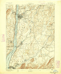
~ Poughkeepsie NY topo map, 1:62500 scale, 15 X 15 Minute, Historical, 1893
Poughkeepsie, New York, USGS topographic map dated 1893.
Includes geographic coordinates (latitude and longitude). This topographic map is suitable for hiking, camping, and exploring, or framing it as a wall map.
Printed on-demand using high resolution imagery, on heavy weight and acid free paper, or alternatively on a variety of synthetic materials.
Topos available on paper, Waterproof, Poly, or Tyvek. Usually shipping rolled, unless combined with other folded maps in one order.
- Product Number: USGS-5453245
- Free digital map download (high-resolution, GeoPDF): Poughkeepsie, New York (file size: 8 MB)
- Map Size: please refer to the dimensions of the GeoPDF map above
- Weight (paper map): ca. 55 grams
- Map Type: POD USGS Topographic Map
- Map Series: HTMC
- Map Verison: Historical
- Cell ID: 61250
- Scan ID: 148221
- Visual Version Number: 1
- Survey Year: 1892
- Datum: Unstated
- Map Projection: Unstated
- Map published by United States Geological Survey
- Map Language: English
- Scanner Resolution: 600 dpi
- Map Cell Name: Poughkeepsie
- Grid size: 15 X 15 Minute
- Date on map: 1893
- Map Scale: 1:62500
- Geographical region: New York, United States
Neighboring Maps:
All neighboring USGS topo maps are available for sale online at a variety of scales.
Spatial coverage:
Topo map Poughkeepsie, New York, covers the geographical area associated the following places:
- Wappingers Falls Mobile Home Park - Billings - Fishkill Landing (historical) - Hughsonville - Little Falls Mobile Home Park - Manchester Bridge - Timothy Heights - Roberts Mobile Home Park - Fairview - Castle Point - Wappingers Falls - Hudson Heights - Crown Heights - Milton - Bahret Mobile Home Park - Shady Brook Mobile Home Park - Knapps Corner - Lagrangeville - Valley Forge Mobile Home Park - Beacon Hills - The Gables - Colonial Heights - Rudco - New Hamburg - Pleasant Valley - Diddell - Strawberry Acres Mobile Home Park - M And K Mobile Home Park - Walnut Lane Mobile Home Park - Birchwood Park - Charlotte Grove Mobile Court - Sheafe Manor Mobile Home Park - Brockway - Freedom Plains - Rombout Ridge - Shady Brook - Camelot Village Mobile Home Park - Ennis Mobile Home Park - East Fishkill - Van Keurens - Rochdale - Fishkill Plains - Manor Hill Mobile Home Park - MacDonnell Heights - Arlington - Beacon - Moorgate Mobile Home Park - Chelsea - Howland - Wiccopee - Titusville - Marlboro - Lomala - Shenandoah - Fishkill - Spackenkill - Cedar Cliff - Poughkeepsie - Red Oaks Mill - Noxon - New Hackensack - Feller Mobile Home Park - Arthursburg - Stoneco - Duchess Park Mobile Home Park - Hillside Lake - Oakes - Myers Corner - Brinckerhoff - Glenham - Groveville - Swartoutville - Highland - Highland Landing - Clark Heights - Roseton - Cooper Road Mobile Home Park - Hopewell Junction - Barnegat
- Map Area ID: AREA41.7541.5-74-73.75
- Northwest corner Lat/Long code: USGSNW41.75-74
- Northeast corner Lat/Long code: USGSNE41.75-73.75
- Southwest corner Lat/Long code: USGSSW41.5-74
- Southeast corner Lat/Long code: USGSSE41.5-73.75
- Northern map edge Latitude: 41.75
- Southern map edge Latitude: 41.5
- Western map edge Longitude: -74
- Eastern map edge Longitude: -73.75


