
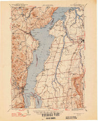
~ Port Henry VT topo map, 1:62500 scale, 15 X 15 Minute, Historical, 1947
Port Henry, Vermont, USGS topographic map dated 1947.
Includes geographic coordinates (latitude and longitude). This topographic map is suitable for hiking, camping, and exploring, or framing it as a wall map.
Printed on-demand using high resolution imagery, on heavy weight and acid free paper, or alternatively on a variety of synthetic materials.
Topos available on paper, Waterproof, Poly, or Tyvek. Usually shipping rolled, unless combined with other folded maps in one order.
- Product Number: USGS-5453163
- Free digital map download (high-resolution, GeoPDF): Port Henry, Vermont (file size: 10 MB)
- Map Size: please refer to the dimensions of the GeoPDF map above
- Weight (paper map): ca. 55 grams
- Map Type: POD USGS Topographic Map
- Map Series: HTMC
- Map Verison: Historical
- Cell ID: 61177
- Scan ID: 129088
- Visual Version Number: 2
- Datum: NAD27
- Map Projection: Polyconic
- Map published by United States Army Corps of Engineers
- Map published by United States Department of War
- Map Language: English
- Scanner Resolution: 600 dpi
- Map Cell Name: Port Henry
- Grid size: 15 X 15 Minute
- Date on map: 1947
- Map Scale: 1:62500
- Geographical region: Vermont, United States
Neighboring Maps:
All neighboring USGS topo maps are available for sale online at a variety of scales.
Spatial coverage:
Topo map Port Henry, Vermont, covers the geographical area associated the following places:
- Panton - Chimney Point - Rock Landing - Port Henry - Wadhams - Ecole Champlain - Palmer Corner - Addison - Goodrich Corner - Westport - Vergennes - Willow Point - West Addison
- Map Area ID: AREA44.2544-73.5-73.25
- Northwest corner Lat/Long code: USGSNW44.25-73.5
- Northeast corner Lat/Long code: USGSNE44.25-73.25
- Southwest corner Lat/Long code: USGSSW44-73.5
- Southeast corner Lat/Long code: USGSSE44-73.25
- Northern map edge Latitude: 44.25
- Southern map edge Latitude: 44
- Western map edge Longitude: -73.5
- Eastern map edge Longitude: -73.25


