
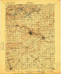
~ Ann Arbor MI topo map, 1:125000 scale, 30 X 30 Minute, Historical, 1904, updated 1917
Ann Arbor, Michigan, USGS topographic map dated 1904.
Includes geographic coordinates (latitude and longitude). This topographic map is suitable for hiking, camping, and exploring, or framing it as a wall map.
Printed on-demand using high resolution imagery, on heavy weight and acid free paper, or alternatively on a variety of synthetic materials.
Topos available on paper, Waterproof, Poly, or Tyvek. Usually shipping rolled, unless combined with other folded maps in one order.
- Product Number: USGS-5443684
- Free digital map download (high-resolution, GeoPDF): Ann Arbor, Michigan (file size: 10 MB)
- Map Size: please refer to the dimensions of the GeoPDF map above
- Weight (paper map): ca. 55 grams
- Map Type: POD USGS Topographic Map
- Map Series: HTMC
- Map Verison: Historical
- Cell ID: 64888
- Scan ID: 278710
- Imprint Year: 1917
- Survey Year: 1902
- Datum: Unstated
- Map Projection: Unstated
- Map published by United States Geological Survey
- Map Language: English
- Scanner Resolution: 600 dpi
- Map Cell Name: Ann Arbor
- Grid size: 30 X 30 Minute
- Date on map: 1904
- Map Scale: 1:125000
- Geographical region: Michigan, United States
Neighboring Maps:
All neighboring USGS topo maps are available for sale online at a variety of scales.
Spatial coverage:
Topo map Ann Arbor, Michigan, covers the geographical area associated the following places:
- West Sumpter - Saline - Whittaker - Dexter - Village Estates Mobile Home Park - Lima Center - Maybee - Pittsfield - Bridgewater - Scio - Lincoln - Cone - Dover - Hell - Kingsley Mobile Park - Northfield - Ann Arbor - Geddes - Edgewater Heights - Sunnyside Mobile Home Park - Tecumseh - Saline Meadows Mobile Home Park - Rushton - Arbor Meadows Mobile Home Park - Hamburg - Paint Creek - Pinckney - Clinton - Parishfield - Willow Run Mobile Home Park - Salem - Lakeview Mobile Home Park - Milan - Green Oak - Lakeland - South Lyon - Hamburg Hills Estates Mobile Home Park - Pettysville - London - Ypsilanti Mobile Home Village - Scio Farms Estates Mobile Home Park - Cherry Hill - Whitmore Lake - Azalia - Swan Creek Mobile Home Community - Denton - Willow Run - Benton - Orchard Grove Village Mobile Home Park - Newburg - Webster - Hudson Mills - Mooreville - Ypsilanti - Rawsonville - Coachville Mobile Park - Rogers Corner - Worden - University Mobile Estates - Macon - Ford Boulevard Mobile Home Park - Stony Creek - Foster - Eastlawn - Saline Mobile Home Park - Dixboro - River Ridge Mobile Home Community - Delhi Mills - Barton Hills - Fourmile Lake - Starlight Mobile Home Park - Elmcrest Mobile Village - Westridge Mobile Home Park - Frain Lake - Northfield Estates Mobile Home Park - Emery - Allen's Trailer Court - Superior - Willis - Brookville - River Raisin - Oakville - York - Jerusalem
- Map Area ID: AREA42.542-84-83.5
- Northwest corner Lat/Long code: USGSNW42.5-84
- Northeast corner Lat/Long code: USGSNE42.5-83.5
- Southwest corner Lat/Long code: USGSSW42-84
- Southeast corner Lat/Long code: USGSSE42-83.5
- Northern map edge Latitude: 42.5
- Southern map edge Latitude: 42
- Western map edge Longitude: -84
- Eastern map edge Longitude: -83.5


