
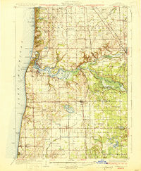
~ Fennville MI topo map, 1:62500 scale, 15 X 15 Minute, Historical, 1931
Fennville, Michigan, USGS topographic map dated 1931.
Includes geographic coordinates (latitude and longitude). This topographic map is suitable for hiking, camping, and exploring, or framing it as a wall map.
Printed on-demand using high resolution imagery, on heavy weight and acid free paper, or alternatively on a variety of synthetic materials.
Topos available on paper, Waterproof, Poly, or Tyvek. Usually shipping rolled, unless combined with other folded maps in one order.
- Product Number: USGS-5442602
- Free digital map download (high-resolution, GeoPDF): Fennville, Michigan (file size: 8 MB)
- Map Size: please refer to the dimensions of the GeoPDF map above
- Weight (paper map): ca. 55 grams
- Map Type: POD USGS Topographic Map
- Map Series: HTMC
- Map Verison: Historical
- Cell ID: 54118
- Scan ID: 278116
- Woodland Tint: Yes
- Survey Year: 1928
- Datum: NAD
- Map Projection: Polyconic
- Map published by United States Geological Survey
- Map Language: English
- Scanner Resolution: 600 dpi
- Map Cell Name: Fennville
- Grid size: 15 X 15 Minute
- Date on map: 1931
- Map Scale: 1:62500
- Geographical region: Michigan, United States
Neighboring Maps:
All neighboring USGS topo maps are available for sale online at a variety of scales.
Spatial coverage:
Topo map Fennville, Michigan, covers the geographical area associated the following places:
- Glenn - Pearl - Old Saugatuck - Saugatuck - Gibson - Macks Landing - Dogwood Manor Mobile Home Park - Singapore (historical) - Pier Cove - Spring Grove - Fennville - Shorewood - Castle Park - Beachmont - Douglas - Grange Corners - Oxbow - Fillmore - Overisel - Bravo - Shorecrest - Douglas Estates Mobile Home Park - Glenn Shores - Shangrai-La Mobile Home Park - Ganges - New Richmond - Hamilton - East Saugatuck - Riverview Mobile Home Park - Country Acres Mobile Home Park
- Map Area ID: AREA42.7542.5-86.25-86
- Northwest corner Lat/Long code: USGSNW42.75-86.25
- Northeast corner Lat/Long code: USGSNE42.75-86
- Southwest corner Lat/Long code: USGSSW42.5-86.25
- Southeast corner Lat/Long code: USGSSE42.5-86
- Northern map edge Latitude: 42.75
- Southern map edge Latitude: 42.5
- Western map edge Longitude: -86.25
- Eastern map edge Longitude: -86


