
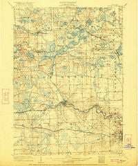
~ Dexter MI topo map, 1:62500 scale, 15 X 15 Minute, Historical, 1906, updated 1921
Dexter, Michigan, USGS topographic map dated 1906.
Includes geographic coordinates (latitude and longitude). This topographic map is suitable for hiking, camping, and exploring, or framing it as a wall map.
Printed on-demand using high resolution imagery, on heavy weight and acid free paper, or alternatively on a variety of synthetic materials.
Topos available on paper, Waterproof, Poly, or Tyvek. Usually shipping rolled, unless combined with other folded maps in one order.
- Product Number: USGS-5442548
- Free digital map download (high-resolution, GeoPDF): Dexter, Michigan (file size: 9 MB)
- Map Size: please refer to the dimensions of the GeoPDF map above
- Weight (paper map): ca. 55 grams
- Map Type: POD USGS Topographic Map
- Map Series: HTMC
- Map Verison: Historical
- Cell ID: 53399
- Scan ID: 278081
- Imprint Year: 1921
- Survey Year: 1902
- Datum: Unstated
- Map Projection: Unstated
- Map published by United States Geological Survey
- Map Language: English
- Scanner Resolution: 600 dpi
- Map Cell Name: Dexter
- Grid size: 15 X 15 Minute
- Date on map: 1906
- Map Scale: 1:62500
- Geographical region: Michigan, United States
Neighboring Maps:
All neighboring USGS topo maps are available for sale online at a variety of scales.
Spatial coverage:
Topo map Dexter, Michigan, covers the geographical area associated the following places:
- Delhi Mills - Barton Hills - University Mobile Estates - Dexter - Scio - Jerusalem - Parishfield - Fourmile Lake - Scio Farms Estates Mobile Home Park - Northfield Estates Mobile Home Park - Pettysville - Hell - Pinckney - Webster - Foster - Dover - Hudson Mills - Starlight Mobile Home Park - Lima Center - Hamburg Hills Estates Mobile Home Park - Lakeland - Hamburg
- Map Area ID: AREA42.542.25-84-83.75
- Northwest corner Lat/Long code: USGSNW42.5-84
- Northeast corner Lat/Long code: USGSNE42.5-83.75
- Southwest corner Lat/Long code: USGSSW42.25-84
- Southeast corner Lat/Long code: USGSSE42.25-83.75
- Northern map edge Latitude: 42.5
- Southern map edge Latitude: 42.25
- Western map edge Longitude: -84
- Eastern map edge Longitude: -83.75


