
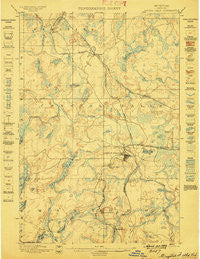
~ Crystal Falls MI topo map, 1:62500 scale, 15 X 15 Minute, Historical, 1899
Crystal Falls, Michigan, USGS topographic map dated 1899.
Includes geographic coordinates (latitude and longitude). This topographic map is suitable for hiking, camping, and exploring, or framing it as a wall map.
Printed on-demand using high resolution imagery, on heavy weight and acid free paper, or alternatively on a variety of synthetic materials.
Topos available on paper, Waterproof, Poly, or Tyvek. Usually shipping rolled, unless combined with other folded maps in one order.
- Product Number: USGS-5442526
- Free digital map download (high-resolution, GeoPDF): Crystal Falls, Michigan (file size: 9 MB)
- Map Size: please refer to the dimensions of the GeoPDF map above
- Weight (paper map): ca. 55 grams
- Map Type: POD USGS Topographic Map
- Map Series: HTMC
- Map Verison: Historical
- Cell ID: 53124
- Scan ID: 278071
- Survey Year: 1885
- Datum: Unstated
- Map Projection: Unstated
- Map published by United States Geological Survey
- Map Language: English
- Scanner Resolution: 600 dpi
- Map Cell Name: Crystal Falls
- Grid size: 15 X 15 Minute
- Date on map: 1899
- Map Scale: 1:62500
- Geographical region: Michigan, United States
Neighboring Maps:
All neighboring USGS topo maps are available for sale online at a variety of scales.
Spatial coverage:
Topo map Crystal Falls, Michigan, covers the geographical area associated the following places:
- Erickson Landing - Monongahela Location - Kelso Junction - Odgers Location - Balsam - Pentoga - Mastodon - Crystal Falls - Amasa - Gibson Lake - Shafer Location - Fortune Lake - New Bristol Location - Panola - Kimball Location - Dunn Location - Western Location - Tobin Location - Alpha
- Map Area ID: AREA46.2546-88.5-88.25
- Northwest corner Lat/Long code: USGSNW46.25-88.5
- Northeast corner Lat/Long code: USGSNE46.25-88.25
- Southwest corner Lat/Long code: USGSSW46-88.5
- Southeast corner Lat/Long code: USGSSE46-88.25
- Northern map edge Latitude: 46.25
- Southern map edge Latitude: 46
- Western map edge Longitude: -88.5
- Eastern map edge Longitude: -88.25


