
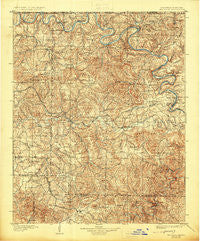
~ Yellville AR topo map, 1:125000 scale, 30 X 30 Minute, Historical, 1905, updated 1925
Yellville, Arkansas, USGS topographic map dated 1905.
Includes geographic coordinates (latitude and longitude). This topographic map is suitable for hiking, camping, and exploring, or framing it as a wall map.
Printed on-demand using high resolution imagery, on heavy weight and acid free paper, or alternatively on a variety of synthetic materials.
Topos available on paper, Waterproof, Poly, or Tyvek. Usually shipping rolled, unless combined with other folded maps in one order.
- Product Number: USGS-5430078
- Free digital map download (high-resolution, GeoPDF): Yellville, Arkansas (file size: 12 MB)
- Map Size: please refer to the dimensions of the GeoPDF map above
- Weight (paper map): ca. 55 grams
- Map Type: POD USGS Topographic Map
- Map Series: HTMC
- Map Verison: Historical
- Cell ID: 66983
- Scan ID: 260576
- Imprint Year: 1925
- Survey Year: 1891
- Datum: Unstated
- Map Projection: Polyconic
- Map published by United States Geological Survey
- Map Language: English
- Scanner Resolution: 600 dpi
- Map Cell Name: Yellville
- Grid size: 30 X 30 Minute
- Date on map: 1905
- Map Scale: 1:125000
- Geographical region: Arkansas, United States
Neighboring Maps:
All neighboring USGS topo maps are available for sale online at a variety of scales.
Spatial coverage:
Topo map Yellville, Arkansas, covers the geographical area associated the following places:
- Valley Springs - Pyatt - Cozahome - Eros - Lakeway - Western Grove - Clutes (historical) - Zinc - Willis - Maumee - Ralph - Winington - Push - Rally Hill - Rea Valley - Mull - Sycamore - Olvey - Flippin - Fairview - Mount Hersey - Cowan - Big Springs (historical) - Oakland - Turkey - Lakeview - Yellville - Monarch - Summit - Powell - Freck - Dugger (historical) - Crawford - Comal - Cotter - Pine Branch - Dugger - Keystone (historical) - Price Place - Harmon - Peel - Georges Creek - Mount Perrian (historical) - Sylvia (historical) - Snow - Bruno - Evening Star - Stone (historical) - Midway - Everton - Amos - Caney - Rush - Pleasant Ridge - Lead Hill - Duff - Tomahawk - Pedlo (historical) - Verona - Kingdom Springs (historical) - Keener - Saint Joe - Bull Shoals - Pindall - South Lead Hill - Dodd City - Diamond City
- Map Area ID: AREA36.536-93-92.5
- Northwest corner Lat/Long code: USGSNW36.5-93
- Northeast corner Lat/Long code: USGSNE36.5-92.5
- Southwest corner Lat/Long code: USGSSW36-93
- Southeast corner Lat/Long code: USGSSE36-92.5
- Northern map edge Latitude: 36.5
- Southern map edge Latitude: 36
- Western map edge Longitude: -93
- Eastern map edge Longitude: -92.5


