
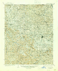
~ Harrison AR topo map, 1:125000 scale, 30 X 30 Minute, Historical, 1905, updated 1945
Harrison, Arkansas, USGS topographic map dated 1905.
Includes geographic coordinates (latitude and longitude). This topographic map is suitable for hiking, camping, and exploring, or framing it as a wall map.
Printed on-demand using high resolution imagery, on heavy weight and acid free paper, or alternatively on a variety of synthetic materials.
Topos available on paper, Waterproof, Poly, or Tyvek. Usually shipping rolled, unless combined with other folded maps in one order.
- Product Number: USGS-5429944
- Free digital map download (high-resolution, GeoPDF): Harrison, Arkansas (file size: 12 MB)
- Map Size: please refer to the dimensions of the GeoPDF map above
- Weight (paper map): ca. 55 grams
- Map Type: POD USGS Topographic Map
- Map Series: HTMC
- Map Verison: Historical
- Cell ID: 65648
- Scan ID: 260497
- Imprint Year: 1945
- Survey Year: 1904
- Datum: Unstated
- Map Projection: Polyconic
- Map published by United States Geological Survey
- Map Language: English
- Scanner Resolution: 600 dpi
- Map Cell Name: Harrison
- Grid size: 30 X 30 Minute
- Date on map: 1905
- Map Scale: 1:125000
- Geographical region: Arkansas, United States
Neighboring Maps:
All neighboring USGS topo maps are available for sale online at a variety of scales.
Spatial coverage:
Topo map Harrison, Arkansas, covers the geographical area associated the following places:
- Hill Top - Delmar - New Hope - Pruitt - Plumlee (historical) - Wooden Hills - Mount Pleasant (historical) - Lick Branch - Rudd - Compton - Nunnally (historical) - Alpena - Bellefonte - Chapman - Denver - Rule - Bergman - Watkins (historical) - Little Buffalo (historical) - Conner - Mount Sherman - Oregon (historical) - Dinsmore - Yocum - Batavia - Flatwoods - Bellville - Osage - Harrison - George - Hasty - Green Forest - Francis - Jasper - Wells Creek (historical) - Grubb Springs - Blue Eye - Farewell - Lowry - Beechwood - Yardelle - Gobbler - Crest - Myrtle - Red Bank - Oakgrove - Self - Maple - Carrollton - Gaither - Brasswell Spring (historical) - Bear Creek Springs - Elmwood - Burlington - Erbie - New Town (historical) - Omaha - The Basin - Boone - Capps - Blue Eye - Sulphur Spring (historical) - Coin - Norton (historical) - Ponca - Hough - Little Arkansaw - Cricket - Hopewell - Dryfork - Raum (historical) - Stoverville - Enon (historical) - Allfriend (historical) - Prosperity - Crumpler Subdivision - Ridgeway - Dogpatch - Shaver (historical) - Cisco
- Map Area ID: AREA36.536-93.5-93
- Northwest corner Lat/Long code: USGSNW36.5-93.5
- Northeast corner Lat/Long code: USGSNE36.5-93
- Southwest corner Lat/Long code: USGSSW36-93.5
- Southeast corner Lat/Long code: USGSSE36-93
- Northern map edge Latitude: 36.5
- Southern map edge Latitude: 36
- Western map edge Longitude: -93.5
- Eastern map edge Longitude: -93


