
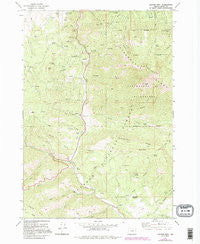
~ Canyon Mtn OR topo map, 1:24000 scale, 7.5 X 7.5 Minute, Historical, 1972, updated 1995
Canyon Mtn, Oregon, USGS topographic map dated 1972.
Includes geographic coordinates (latitude and longitude). This topographic map is suitable for hiking, camping, and exploring, or framing it as a wall map.
Printed on-demand using high resolution imagery, on heavy weight and acid free paper, or alternatively on a variety of synthetic materials.
Topos available on paper, Waterproof, Poly, or Tyvek. Usually shipping rolled, unless combined with other folded maps in one order.
- Product Number: USGS-5417194
- Free digital map download (high-resolution, GeoPDF): Canyon Mtn, Oregon (file size: 14 MB)
- Map Size: please refer to the dimensions of the GeoPDF map above
- Weight (paper map): ca. 55 grams
- Map Type: POD USGS Topographic Map
- Map Series: HTMC
- Map Verison: Historical
- Cell ID: 7140
- Scan ID: 279263
- Imprint Year: 1995
- Woodland Tint: Yes
- Photo Revision Year: 1980
- Aerial Photo Year: 1981
- Field Check Year: 1972
- Datum: NAD27
- Map Projection: Lambert Conformal Conic
- Map published by United States Geological Survey
- Map Language: English
- Scanner Resolution: 600 dpi
- Map Cell Name: Canyon Mountain
- Grid size: 7.5 X 7.5 Minute
- Date on map: 1972
- Map Scale: 1:24000
- Geographical region: Oregon, United States
Neighboring Maps:
All neighboring USGS topo maps are available for sale online at a variety of scales.
Spatial coverage:
Topo map Canyon Mtn, Oregon, covers the geographical area associated the following places:
- Gold Creek - Mud Spring - Hot Springs - Deer Creek - West Fork East Gulch - Miller Mountain Mine - Watson Gulch - Alder Gulch - Cougar Camp - Big Rock - Willow Spring - East Gulch - Eagle Peak - Cherry Gulch - Joaquin Miller Recreation Site - Great Northern Mine - Dry Gulch - New Mine - Little Canyon Mountain - Haggard Mine - Jack Cabin Meadow - Guernsey Pond - Corral Gulch - Berry Creek - Fawn Creek - Iron King Mine - Mosier Camp - Golden West Mine - Alder Spring - Vance Creek - Rattlesnake Spring - Road Gulch - J Bar L Ranch - Wall Creek - Maiden Spring - Fawn Spring Trail - Painters Gulch - Fawn Spring - Overholt Creek - Canyon Mountain Trailhead - Canyon Mountain Recreation Site (historical) - Canyon Mountain - Byram Gulch - Rattlesnake Ridge - South Fork Vance Creek - Joaquin Miller Trail - Ray Cole Campground - East Fork Canyon Creek Trailhead - Sheep Rock - Cougar Creek - Miller Mountain - Horseshoe Bar - Canyon City Municipal Watershed - Sheep Gulch - Mud Lake - Rabbit Ridge - Rhodabush Creek - Vance Creek Safety Rest Area (historical) - Joaquin Miller Trailhead - Soda Gulch - Williams Ranch - Grouse Creek - Bear Gulch
- Map Area ID: AREA44.37544.25-119-118.875
- Northwest corner Lat/Long code: USGSNW44.375-119
- Northeast corner Lat/Long code: USGSNE44.375-118.875
- Southwest corner Lat/Long code: USGSSW44.25-119
- Southeast corner Lat/Long code: USGSSE44.25-118.875
- Northern map edge Latitude: 44.375
- Southern map edge Latitude: 44.25
- Western map edge Longitude: -119
- Eastern map edge Longitude: -118.875


