
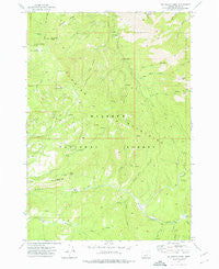
~ Big Weasel Sprs OR topo map, 1:24000 scale, 7.5 X 7.5 Minute, Historical, 1972, updated 1976
Big Weasel Sprs, Oregon, USGS topographic map dated 1972.
Includes geographic coordinates (latitude and longitude). This topographic map is suitable for hiking, camping, and exploring, or framing it as a wall map.
Printed on-demand using high resolution imagery, on heavy weight and acid free paper, or alternatively on a variety of synthetic materials.
Topos available on paper, Waterproof, Poly, or Tyvek. Usually shipping rolled, unless combined with other folded maps in one order.
- Product Number: USGS-5416730
- Free digital map download (high-resolution, GeoPDF): Big Weasel Sprs, Oregon (file size: 12 MB)
- Map Size: please refer to the dimensions of the GeoPDF map above
- Weight (paper map): ca. 55 grams
- Map Type: POD USGS Topographic Map
- Map Series: HTMC
- Map Verison: Historical
- Cell ID: 3881
- Scan ID: 279035
- Imprint Year: 1976
- Woodland Tint: Yes
- Aerial Photo Year: 1971
- Field Check Year: 1972
- Datum: NAD27
- Map Projection: Lambert Conformal Conic
- Map published by United States Geological Survey
- Map Language: English
- Scanner Resolution: 600 dpi
- Map Cell Name: Big Weasel Springs
- Grid size: 7.5 X 7.5 Minute
- Date on map: 1972
- Map Scale: 1:24000
- Geographical region: Oregon, United States
Neighboring Maps:
All neighboring USGS topo maps are available for sale online at a variety of scales.
Spatial coverage:
Topo map Big Weasel Sprs, Oregon, covers the geographical area associated the following places:
- Aldrich Mountains - Murderers Creek Forest Service Station - Oregon Mine - Dry Creek Butte - Cedar Grove Botanical Area - Big Weasel Springs - Last Camp - Shaw Spring - Buck Cabin - Separation Corrals Camp - Oregon Mine Creek - Little Weasel Spring - Tex Creek Arch - Lemon Cabin - Last Creek - Fields Peak - Thorn Creek Butte - Lemon Creek - Stewart Cabin - China Hat Spring - Wickiup Creek - Billy Fields Recreation Site - Horse Creek - Oregon Mine Recreation Site - Tennessee Creek - Hattie Spring - Orange Creek - Dans Creek - Buck Cabin Creek - Beaver Creek - Frankie and Johnny Spring - Hattie Creek - Chrome Ridge - Tex Creek - Big Canyon Spring - Hells Canyon Creek - Oregon Mine Camp - Buck Cabin Trail
- Map Area ID: AREA44.37544.25-119.375-119.25
- Northwest corner Lat/Long code: USGSNW44.375-119.375
- Northeast corner Lat/Long code: USGSNE44.375-119.25
- Southwest corner Lat/Long code: USGSSW44.25-119.375
- Southeast corner Lat/Long code: USGSSE44.25-119.25
- Northern map edge Latitude: 44.375
- Southern map edge Latitude: 44.25
- Western map edge Longitude: -119.375
- Eastern map edge Longitude: -119.25


