
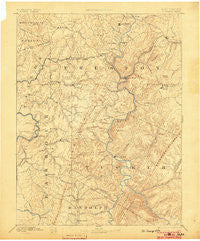
~ St George WV topo map, 1:125000 scale, 30 X 30 Minute, Historical, 1891, updated 1903
St George, West Virginia, USGS topographic map dated 1891.
Includes geographic coordinates (latitude and longitude). This topographic map is suitable for hiking, camping, and exploring, or framing it as a wall map.
Printed on-demand using high resolution imagery, on heavy weight and acid free paper, or alternatively on a variety of synthetic materials.
Topos available on paper, Waterproof, Poly, or Tyvek. Usually shipping rolled, unless combined with other folded maps in one order.
- Product Number: USGS-5416164
- Free digital map download (high-resolution, GeoPDF): St George, West Virginia (file size: 9 MB)
- Map Size: please refer to the dimensions of the GeoPDF map above
- Weight (paper map): ca. 55 grams
- Map Type: POD USGS Topographic Map
- Map Series: HTMC
- Map Verison: Historical
- Cell ID: 66291
- Scan ID: 254018
- Imprint Year: 1903
- Survey Year: 1885
- Datum: Unstated
- Map Projection: Unstated
- Map published by United States Geological Survey
- Map Language: English
- Scanner Resolution: 600 dpi
- Map Cell Name: Parsons
- Grid size: 30 X 30 Minute
- Date on map: 1891
- Map Scale: 1:125000
- Geographical region: West Virginia, United States
Neighboring Maps:
All neighboring USGS topo maps are available for sale online at a variety of scales.
Spatial coverage:
Topo map St George, West Virginia, covers the geographical area associated the following places:
- Mackeyville - Preston - Hobson (historical) - Montrose - Manown - Gladesville - Pleasant Run - Clover Run (historical) - Hardesty - Aurora - Hendricks - Evansville - Snider - Lead Mine - Westerman (historical) - Towson (historical) - Mill Run (historical) - Loftis (historical) - West End - Howesville - Brookside - Victoria - Etam - Millertown - Caddell - Amboy - Zevely - Manheim - Macomber - Pleasure Valley - Saint George - Tacy - Belington - Mount Olivet - Douglas - Cove Run - Salt Lick - Kirt - Knottsville - Sell - Amblersburg - Jessop - Wilmoth (historical) - Borgman - Eby - Cecil - Jones - Kerens - Corley - Hambleton - Atlantic (historical) - Brownlow - Denver - Lehigh (historical) - Moore - Tunnelton - Buckhorn (historical) - Dantown (historical) - Nestorville - Freeport - White Oak Springs - Moatsville - Kingwood - Auvil - Marquess - Thornton - Valley Bend - Arthurdale - Pettit (historical) - Meadowville - Clemtown - Concord - Elk - Dent - Stringtown - Lime Rock (historical) - Eglon - Claude - Mountain View - Alston - Rodemer - Kanetown - Saint Joe - Mountain View - Porterwood - Israel - Rowlesburg - Independence - Irona - Scotch Hill - Sinclair - Rosendorf - Smith Crossing - Lesmalinston - Horse Shoe Run - Hannahsville - McLean (historical) - Threefork Bridge - Holly Meadows - Cove Run Station (historical)
- Map Area ID: AREA39.539-80-79.5
- Northwest corner Lat/Long code: USGSNW39.5-80
- Northeast corner Lat/Long code: USGSNE39.5-79.5
- Southwest corner Lat/Long code: USGSSW39-80
- Southeast corner Lat/Long code: USGSSE39-79.5
- Northern map edge Latitude: 39.5
- Southern map edge Latitude: 39
- Western map edge Longitude: -80
- Eastern map edge Longitude: -79.5


