
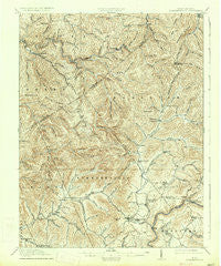
~ Summersville WV topo map, 1:62500 scale, 15 X 15 Minute, Historical, 1915, updated 1934
Summersville, West Virginia, USGS topographic map dated 1915.
Includes geographic coordinates (latitude and longitude). This topographic map is suitable for hiking, camping, and exploring, or framing it as a wall map.
Printed on-demand using high resolution imagery, on heavy weight and acid free paper, or alternatively on a variety of synthetic materials.
Topos available on paper, Waterproof, Poly, or Tyvek. Usually shipping rolled, unless combined with other folded maps in one order.
- Product Number: USGS-5415926
- Free digital map download (high-resolution, GeoPDF): Summersville, West Virginia (file size: 12 MB)
- Map Size: please refer to the dimensions of the GeoPDF map above
- Weight (paper map): ca. 55 grams
- Map Type: POD USGS Topographic Map
- Map Series: HTMC
- Map Verison: Historical
- Cell ID: 63090
- Scan ID: 253869
- Imprint Year: 1934
- Survey Year: 1913
- Datum: NAD
- Map Projection: Polyconic
- Map published by United States Geological Survey
- Map Language: English
- Scanner Resolution: 600 dpi
- Map Cell Name: Summersville
- Grid size: 15 X 15 Minute
- Date on map: 1915
- Map Scale: 1:62500
- Geographical region: West Virginia, United States
Neighboring Maps:
All neighboring USGS topo maps are available for sale online at a variety of scales.
Spatial coverage:
Topo map Summersville, West Virginia, covers the geographical area associated the following places:
- Poe - Harriet - Tara Estates - Kirkwood - Persinger - Hookersville - Enon - Pine Trailer Park - Widen - Opal - Cressmont - Glade Creek - Wattsville - Dille - Drennen - Summersville - Cornelia - Werth - Tipton - Canvas - Enoch - Muddlety - Burl - Gilboa - Eakle - Swandale - Holly Hills Estates - Birch River - Zela - Bright Mountain Estates
- Map Area ID: AREA38.538.25-81-80.75
- Northwest corner Lat/Long code: USGSNW38.5-81
- Northeast corner Lat/Long code: USGSNE38.5-80.75
- Southwest corner Lat/Long code: USGSSW38.25-81
- Southeast corner Lat/Long code: USGSSE38.25-80.75
- Northern map edge Latitude: 38.5
- Southern map edge Latitude: 38.25
- Western map edge Longitude: -81
- Eastern map edge Longitude: -80.75


