
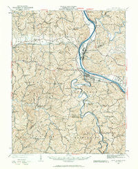
~ Saint Albans WV topo map, 1:62500 scale, 15 X 15 Minute, Historical, 1931, updated 1961
Saint Albans, West Virginia, USGS topographic map dated 1931.
Includes geographic coordinates (latitude and longitude). This topographic map is suitable for hiking, camping, and exploring, or framing it as a wall map.
Printed on-demand using high resolution imagery, on heavy weight and acid free paper, or alternatively on a variety of synthetic materials.
Topos available on paper, Waterproof, Poly, or Tyvek. Usually shipping rolled, unless combined with other folded maps in one order.
- Product Number: USGS-5415870
- Free digital map download (high-resolution, GeoPDF): Saint Albans, West Virginia (file size: 12 MB)
- Map Size: please refer to the dimensions of the GeoPDF map above
- Weight (paper map): ca. 55 grams
- Map Type: POD USGS Topographic Map
- Map Series: HTMC
- Map Verison: Historical
- Cell ID: 61914
- Scan ID: 253843
- Imprint Year: 1961
- Survey Year: 1907
- Datum: NAD27
- Map Projection: Polyconic
- Map published by United States Geological Survey
- Map Language: English
- Scanner Resolution: 600 dpi
- Map Cell Name: Saint Albans
- Grid size: 15 X 15 Minute
- Date on map: 1931
- Map Scale: 1:62500
- Geographical region: West Virginia, United States
Neighboring Maps:
All neighboring USGS topo maps are available for sale online at a variety of scales.
Spatial coverage:
Topo map Saint Albans, West Virginia, covers the geographical area associated the following places:
- Lone Oak Park - Strawberry Heights - Teays Meadow - Ferrell - Belvil Park - Scott Village - Teays Farm - Cherry Grove - Woods and Irons - Autumn Wynds - Englewood Estates - Winsor Court - Woods and Irons East - Woods and Irons South - Marlaina Addition - Indian (historical) - Twin Rivers Mobile Home Park - Poca - Alum Creek - Belle Acres - Beech Park Acres - Roseville Addition - East Nitro - Teays Villa - Candlewyck Place - Scott Depot - Green Valley - Oakwood Estates - Teays Village - Hickory Hill - Rock Branch - Tyler Heights - Sproul - Nitro - Tornado - Teays Valley Meadows - Dogwood Estates - Fuquay (historical) - Saint Albans - Jefferson - Sweet Acres - Riverside Mobile Home Park - Springdale Estates - Lower Falls - Parkway Terrace - Sun Valley Estates - Black Betsey - Calvert (historical) - Saunders Addition - Rolling Meadows - Sleepy Hollow Township - Riverlake - Morgans Landing - Baker Park - Mount Vernon Meadows - Sun Valley - Country Villas - Glass Addition - Cheyenne Valley - Ranch Lake Estates - Arborland Acres - Windsong Acres - Garretts Bend - Fairview - Valley Brook Mobile Home Park - Tango - River Bend - Ortin Heights - Kenmar Trailer Park - Highlawn - Ballard (historical) - Silver Valley Estates - Scary - Lexington Estates - Valley View Estates - Priestley - Forks of Coal - Springlea Estates - Lincoln (historical) - Lincoln Park - Riverdale Acres - Cross Lanes - Black Lick Estates - Teays - Raymond City - The Ridge Estates - Virginia Heights - Teays Valley Estates - Colonial Gardens - Sattes - Teays Valley - Poplar Point Estates - Fairway Gardens - Amandaville - Woodcliffe Chase - Institute - Hidden Valley Estates
- Map Area ID: AREA38.538.25-82-81.75
- Northwest corner Lat/Long code: USGSNW38.5-82
- Northeast corner Lat/Long code: USGSNE38.5-81.75
- Southwest corner Lat/Long code: USGSSW38.25-82
- Southeast corner Lat/Long code: USGSSE38.25-81.75
- Northern map edge Latitude: 38.5
- Southern map edge Latitude: 38.25
- Western map edge Longitude: -82
- Eastern map edge Longitude: -81.75


