
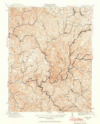
~ Mullens WV topo map, 1:62500 scale, 15 X 15 Minute, Historical, 1925, updated 1966
Mullens, West Virginia, USGS topographic map dated 1925.
Includes geographic coordinates (latitude and longitude). This topographic map is suitable for hiking, camping, and exploring, or framing it as a wall map.
Printed on-demand using high resolution imagery, on heavy weight and acid free paper, or alternatively on a variety of synthetic materials.
Topos available on paper, Waterproof, Poly, or Tyvek. Usually shipping rolled, unless combined with other folded maps in one order.
- Product Number: USGS-5415660
- Free digital map download (high-resolution, GeoPDF): Mullens, West Virginia (file size: 12 MB)
- Map Size: please refer to the dimensions of the GeoPDF map above
- Weight (paper map): ca. 55 grams
- Map Type: POD USGS Topographic Map
- Map Series: HTMC
- Map Verison: Historical
- Cell ID: 58182
- Scan ID: 253730
- Imprint Year: 1966
- Survey Year: 1910
- Datum: NAD27
- Map Projection: Polyconic
- Map published by United States Geological Survey
- Map Language: English
- Scanner Resolution: 600 dpi
- Map Cell Name: Mullens
- Grid size: 15 X 15 Minute
- Date on map: 1925
- Map Scale: 1:62500
- Geographical region: West Virginia, United States
Neighboring Maps:
All neighboring USGS topo maps are available for sale online at a variety of scales.
Spatial coverage:
Topo map Mullens, West Virginia, covers the geographical area associated the following places:
- Nuriva - Montecarlo - Beechwood - Ravencliff - Hoohoo - New Richmond - Amigo - Ury - Itmann - Bud - Hotchkiss - Madeline - Blackeagle - Newfound - Iroquois - Big Stick - Stotesbury - McGraws - Eastgulf - Glen White - Jenny Gap (historical) - Otsego - Rhodell - Tams - Maben - Pierpont - Lester - Wyco - Killarney - Saulsville - Sophia - Glen View - Basin - Mullens - Allen Junction - Stonecoal Junction - Herndon Heights - Stephenson - Maple Meadow - Milam - Helen - Tralee - Slab Fork - Herndon - Corinne - McAlpin - Polk Gap - Woodbay (historical) - Glen Rogers - Mead - Elmore - Joe Branch - Alpoca
- Map Area ID: AREA37.7537.5-81.5-81.25
- Northwest corner Lat/Long code: USGSNW37.75-81.5
- Northeast corner Lat/Long code: USGSNE37.75-81.25
- Southwest corner Lat/Long code: USGSSW37.5-81.5
- Southeast corner Lat/Long code: USGSSE37.5-81.25
- Northern map edge Latitude: 37.75
- Southern map edge Latitude: 37.5
- Western map edge Longitude: -81.5
- Eastern map edge Longitude: -81.25


