
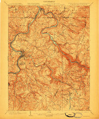
~ Morgantown WV topo map, 1:62500 scale, 15 X 15 Minute, Historical, 1902, updated 1910
Morgantown, West Virginia, USGS topographic map dated 1902.
Includes geographic coordinates (latitude and longitude). This topographic map is suitable for hiking, camping, and exploring, or framing it as a wall map.
Printed on-demand using high resolution imagery, on heavy weight and acid free paper, or alternatively on a variety of synthetic materials.
Topos available on paper, Waterproof, Poly, or Tyvek. Usually shipping rolled, unless combined with other folded maps in one order.
- Product Number: USGS-5415640
- Free digital map download (high-resolution, GeoPDF): Morgantown, West Virginia (file size: 12 MB)
- Map Size: please refer to the dimensions of the GeoPDF map above
- Weight (paper map): ca. 55 grams
- Map Type: POD USGS Topographic Map
- Map Series: HTMC
- Map Verison: Historical
- Cell ID: 57885
- Scan ID: 253717
- Imprint Year: 1910
- Survey Year: 1900
- Datum: Unstated
- Map Projection: Unstated
- Map published by United States Geological Survey
- Map Language: English
- Scanner Resolution: 600 dpi
- Map Cell Name: Morgantown
- Grid size: 15 X 15 Minute
- Date on map: 1902
- Map Scale: 1:62500
- Geographical region: West Virginia, United States
Neighboring Maps:
All neighboring USGS topo maps are available for sale online at a variety of scales.
Spatial coverage:
Topo map Morgantown, West Virginia, covers the geographical area associated the following places:
- West Van Voorhis - Hoard - Fairmor - Sabraton - Crystal - Lake Lynn - Cheat Neck - Burk - Morgantown - Nilan - Sunset Beach - The Flatts - Seneca - Hog Eye - Greer - Virginia Manor - Granville - Mount Vernon - Point Marion - South Park - McMellin (historical) - Davidson - Little Falls - Fort Martin - Gum Spring - The Mileground - North Hills - Jaco - Rock Forge - Braewick Woods - Masontown - West Point Marion - Bertha Hill - Baker Ridge - Sunnyside - Morgan Heights - Cheat Lake - Hilderbrand - Sturgisson - McKinley Hill - Westover - Greystone - Suncrest - Chestnut Ridge - West Sabraton - Pioneer Rocks - Riverside - Dunkard - Hopecrest - Reedsville - Wymps Gap - Guseman - Ringgold - Jerome Park - Park Hills - Springhill - Evansdale - Canyon - Dellslow - Pierpont - Pisgah - Tanglewood - Price Hill - Blosser Hill - Rohr - Oakview - Randall - Easton - Woodburn - Maidsville - Stewartstown - Star City - Suncrest Lake - South Hills - Harmony Grove - Walnut Hill - Bretz - Richard - Kanes Creek - Rosedale - Clinton Furnace - Bull Run - Wiles Hill - Uffington - Brewer Hill - Cascade - Fieldcrest - Van Voorhis - Tyrone - Brookhaven - Gans - Ridgedale - Pineridge North
- Map Area ID: AREA39.7539.5-80-79.75
- Northwest corner Lat/Long code: USGSNW39.75-80
- Northeast corner Lat/Long code: USGSNE39.75-79.75
- Southwest corner Lat/Long code: USGSSW39.5-80
- Southeast corner Lat/Long code: USGSSE39.5-79.75
- Northern map edge Latitude: 39.75
- Southern map edge Latitude: 39.5
- Western map edge Longitude: -80
- Eastern map edge Longitude: -79.75


