
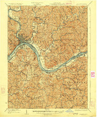
~ Marietta WV topo map, 1:62500 scale, 15 X 15 Minute, Historical, 1927
Marietta, West Virginia, USGS topographic map dated 1927.
Includes geographic coordinates (latitude and longitude). This topographic map is suitable for hiking, camping, and exploring, or framing it as a wall map.
Printed on-demand using high resolution imagery, on heavy weight and acid free paper, or alternatively on a variety of synthetic materials.
Topos available on paper, Waterproof, Poly, or Tyvek. Usually shipping rolled, unless combined with other folded maps in one order.
- Product Number: USGS-5415532
- Free digital map download (high-resolution, GeoPDF): Marietta, West Virginia (file size: 14 MB)
- Map Size: please refer to the dimensions of the GeoPDF map above
- Weight (paper map): ca. 55 grams
- Map Type: POD USGS Topographic Map
- Map Series: HTMC
- Map Verison: Historical
- Cell ID: 57150
- Scan ID: 253663
- Survey Year: 1902
- Datum: NAD
- Map Projection: Polyconic
- Map published by United States Geological Survey
- Map Language: English
- Scanner Resolution: 600 dpi
- Map Cell Name: Maretta
- Grid size: 15 X 15 Minute
- Date on map: 1927
- Map Scale: 1:62500
- Geographical region: West Virginia, United States
Neighboring Maps:
All neighboring USGS topo maps are available for sale online at a variety of scales.
Spatial coverage:
Topo map Marietta, West Virginia, covers the geographical area associated the following places:
- Valley Manor Addition - Devola - Willow Island - Marietta - Arlington Heights - Ruraldale - Belmont - Greenbrier Addition - Pohick - East Norwood Trailer Park - Scenic Hills - Schley - Sand Hill - Unionville - Newlandsville - Southgate Mobile Home Park - Longvue - Lower Newport - Mustang Acres - Fairview Heights - Western Hills - Tallyho - Fay - Dart - Cluster - Doyle - Sandhill - Emerson Heights - Cornerville - Williamstown - Rathbone Heights - Riverdale - Ogden - Boreman - Valley Mills - Sandhill - Parkers Towne - Ponderosa - Liberty Hills - Emerson - Parish-Morris Subdivision - Sitka - Corbin (historical) - North Hills - Rathbone - Westview - Oak Grove - Muskingum Terrace - Dell - Grand View - Mount Everett - Friendly Acres - Oakwood Estates - Moore Junction - Yankeeburg - Pinehurst - Morningside - Winding Road Addition - Caywood - Hills - Harmar - Delaney (historical) - Putnam Place - Steel Run - Parmeta Crest - Newell Run - West Marietta - Elmwood Heights - Stanleyville - Eureka - Horseneck - Rainbow - East Norwood - Norwood Mobile Home Park - Northwood Villa Estates - Waverly - Green Meadows Addition - Cow Run - Rolling Hills - Brierwood - Borland - Gracey - Moss Run - Marietta Marina Trailer Park - Deerwalk - Springdale - Oakwood Park - Norwood - Hillcrest - Eastwood Addition - Reno - Ashby Ridge Estates
- Map Area ID: AREA39.539.25-81.5-81.25
- Northwest corner Lat/Long code: USGSNW39.5-81.5
- Northeast corner Lat/Long code: USGSNE39.5-81.25
- Southwest corner Lat/Long code: USGSSW39.25-81.5
- Southeast corner Lat/Long code: USGSSE39.25-81.25
- Northern map edge Latitude: 39.5
- Southern map edge Latitude: 39.25
- Western map edge Longitude: -81.5
- Eastern map edge Longitude: -81.25


