
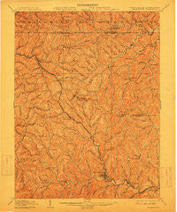
~ Mannington WV topo map, 1:62500 scale, 15 X 15 Minute, Historical, 1905, updated 1912
Mannington, West Virginia, USGS topographic map dated 1905.
Includes geographic coordinates (latitude and longitude). This topographic map is suitable for hiking, camping, and exploring, or framing it as a wall map.
Printed on-demand using high resolution imagery, on heavy weight and acid free paper, or alternatively on a variety of synthetic materials.
Topos available on paper, Waterproof, Poly, or Tyvek. Usually shipping rolled, unless combined with other folded maps in one order.
- Product Number: USGS-5415524
- Free digital map download (high-resolution, GeoPDF): Mannington, West Virginia (file size: 13 MB)
- Map Size: please refer to the dimensions of the GeoPDF map above
- Weight (paper map): ca. 55 grams
- Map Type: POD USGS Topographic Map
- Map Series: HTMC
- Map Verison: Historical
- Cell ID: 57113
- Scan ID: 253658
- Imprint Year: 1912
- Survey Year: 1903
- Datum: Unstated
- Map Projection: Unstated
- Map published by United States Geological Survey
- Map Language: English
- Scanner Resolution: 600 dpi
- Map Cell Name: Mannington
- Grid size: 15 X 15 Minute
- Date on map: 1905
- Map Scale: 1:62500
- Geographical region: West Virginia, United States
Neighboring Maps:
All neighboring USGS topo maps are available for sale online at a variety of scales.
Spatial coverage:
Topo map Mannington, West Virginia, covers the geographical area associated the following places:
- Brink - Round Bottom - Condit - Miracle Run - Flyblow (historical) - Crossroads - Hundred - Satterfield (historical) - Saint Leo - Klondike - Mannington - Homewood - Ned - Jollytown - Rymer - Sandrock - Consol Number 9 - Hero - Deep Valley - Rachel - Cusicks Crossing - Metz - Maple - Wana - Garrison - Downs - Shamrock - Logansport - Wadestown - Bula - Kimberly - Burton - Seven Pines - Curtisville - Ragtown - McClellan - Cottontown - Earnshaw - Brave - Hunting Hills - Saint Cloud
- Map Area ID: AREA39.7539.5-80.5-80.25
- Northwest corner Lat/Long code: USGSNW39.75-80.5
- Northeast corner Lat/Long code: USGSNE39.75-80.25
- Southwest corner Lat/Long code: USGSSW39.5-80.5
- Southeast corner Lat/Long code: USGSSE39.5-80.25
- Northern map edge Latitude: 39.75
- Southern map edge Latitude: 39.5
- Western map edge Longitude: -80.5
- Eastern map edge Longitude: -80.25


