
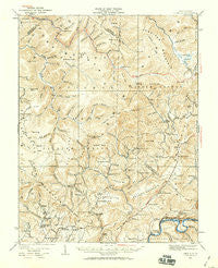
~ Lobelia WV topo map, 1:62500 scale, 15 X 15 Minute, Historical, 1935, updated 1959
Lobelia, West Virginia, USGS topographic map dated 1935.
Includes geographic coordinates (latitude and longitude). This topographic map is suitable for hiking, camping, and exploring, or framing it as a wall map.
Printed on-demand using high resolution imagery, on heavy weight and acid free paper, or alternatively on a variety of synthetic materials.
Topos available on paper, Waterproof, Poly, or Tyvek. Usually shipping rolled, unless combined with other folded maps in one order.
- Product Number: USGS-5415488
- Free digital map download (high-resolution, GeoPDF): Lobelia, West Virginia (file size: 11 MB)
- Map Size: please refer to the dimensions of the GeoPDF map above
- Weight (paper map): ca. 55 grams
- Map Type: POD USGS Topographic Map
- Map Series: HTMC
- Map Verison: Historical
- Cell ID: 56820
- Scan ID: 253634
- Imprint Year: 1959
- Survey Year: 1923
- Datum: NAD27
- Map Projection: Polyconic
- Map published by United States Geological Survey
- Map Language: English
- Scanner Resolution: 600 dpi
- Map Cell Name: Lobelia
- Grid size: 15 X 15 Minute
- Date on map: 1935
- Map Scale: 1:62500
- Geographical region: West Virginia, United States
Neighboring Maps:
All neighboring USGS topo maps are available for sale online at a variety of scales.
Spatial coverage:
Topo map Lobelia, West Virginia, covers the geographical area associated the following places:
- Trout - Golden - Horrock - Cordova - Jacox - Esty - Oscar - Julia - Lobelia - Leonard - Dogway - Whiteoak Grove - Loveridge - Friars Hill - North Bend - Modoc - Rorer - Droop - Spice - Renicks Valley - Droop Mountain
- Map Area ID: AREA38.2538-80.5-80.25
- Northwest corner Lat/Long code: USGSNW38.25-80.5
- Northeast corner Lat/Long code: USGSNE38.25-80.25
- Southwest corner Lat/Long code: USGSSW38-80.5
- Southeast corner Lat/Long code: USGSSE38-80.25
- Northern map edge Latitude: 38.25
- Southern map edge Latitude: 38
- Western map edge Longitude: -80.5
- Eastern map edge Longitude: -80.25


