
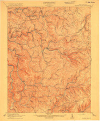
~ Hacker Valley WV topo map, 1:62500 scale, 15 X 15 Minute, Historical, 1915
Hacker Valley, West Virginia, USGS topographic map dated 1915.
Includes geographic coordinates (latitude and longitude). This topographic map is suitable for hiking, camping, and exploring, or framing it as a wall map.
Printed on-demand using high resolution imagery, on heavy weight and acid free paper, or alternatively on a variety of synthetic materials.
Topos available on paper, Waterproof, Poly, or Tyvek. Usually shipping rolled, unless combined with other folded maps in one order.
- Product Number: USGS-5415378
- Free digital map download (high-resolution, GeoPDF): Hacker Valley, West Virginia (file size: 8 MB)
- Map Size: please refer to the dimensions of the GeoPDF map above
- Weight (paper map): ca. 55 grams
- Map Type: POD USGS Topographic Map
- Map Series: HTMC
- Map Verison: Historical
- Cell ID: 320606
- Scan ID: 700809
- Survey Year: 1913
- Datum: Unstated
- Map Projection: Unstated
- Map published by United States Geological Survey
- Map Language: English
- Scanner Resolution: 508 dpi
- Map Cell Name: Hacker Valley
- Grid size: 15 X 15 Minute
- Date on map: 1915
- Map Scale: 1:62500
- Geographical region: West Virginia, United States
Neighboring Maps:
All neighboring USGS topo maps are available for sale online at a variety of scales.
Spatial coverage:
Topo map Hacker Valley, West Virginia, covers the geographical area associated the following places:
- Jumbo - Arvondale - Bernardstown - Cleveland - Penbro (historical) - Mayton (historical) - Poling - Fishers Crossing - Replete - Kovan - Bois - Hodam - Chapman - Woodzell - Wildcat (historical) - Skelt - Diana - Craddock - Big Run - Orndoff - Goshen - Suncrest - Wheeler - Vernon - Canaan - Pugh - Eden - Guardian - Hacker Valley
- Map Area ID: AREA38.7538.5-80.5-80.25
- Northwest corner Lat/Long code: USGSNW38.75-80.5
- Northeast corner Lat/Long code: USGSNE38.75-80.25
- Southwest corner Lat/Long code: USGSSW38.5-80.5
- Southeast corner Lat/Long code: USGSSE38.5-80.25
- Northern map edge Latitude: 38.75
- Southern map edge Latitude: 38.5
- Western map edge Longitude: -80.5
- Eastern map edge Longitude: -80.25


