
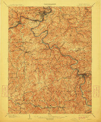
~ Fairmont WV topo map, 1:62500 scale, 15 X 15 Minute, Historical, 1902, updated 1913
Fairmont, West Virginia, USGS topographic map dated 1902.
Includes geographic coordinates (latitude and longitude). This topographic map is suitable for hiking, camping, and exploring, or framing it as a wall map.
Printed on-demand using high resolution imagery, on heavy weight and acid free paper, or alternatively on a variety of synthetic materials.
Topos available on paper, Waterproof, Poly, or Tyvek. Usually shipping rolled, unless combined with other folded maps in one order.
- Product Number: USGS-5415244
- Free digital map download (high-resolution, GeoPDF): Fairmont, West Virginia (file size: 13 MB)
- Map Size: please refer to the dimensions of the GeoPDF map above
- Weight (paper map): ca. 55 grams
- Map Type: POD USGS Topographic Map
- Map Series: HTMC
- Map Verison: Historical
- Cell ID: 54046
- Scan ID: 253503
- Imprint Year: 1913
- Survey Year: 1901
- Datum: Unstated
- Map Projection: Unstated
- Map published by United States Geological Survey
- Map Language: English
- Scanner Resolution: 600 dpi
- Map Cell Name: Fairmont
- Grid size: 15 X 15 Minute
- Date on map: 1902
- Map Scale: 1:62500
- Geographical region: West Virginia, United States
Neighboring Maps:
All neighboring USGS topo maps are available for sale online at a variety of scales.
Spatial coverage:
Topo map Fairmont, West Virginia, covers the geographical area associated the following places:
- Hillcrest - Grafton - McGee - Adamsville - Meadland - Fairmont - Ryanville - White Hall - Brittain (historical) - Hepzibah - Westchester - Graham Heights - Jayenn - Flemington - Simpson - Pettyjohn (historical) - Rosemont - Buffalo Station (historical) - Hopewell - Fetterman - Garden Village - Pleasant Valley - Pruntytown - Norway - Meadowdale - Bendolph - Vernon Heights - Lake Ridge - Elliotsville - Valley Falls - Canton - Boothsville - Gaston - Santiago - Shagtown - Samaria - Oral Lake - Kingmont - Millersville - West End - Wahoo - Powell - Wendel - Yates (historical) - Norwood - Tappan - Park View - Gath (historical) - Bentons Ferry - Belgium - South Grafton - Everson - Middleville - Maple Lake - Edgemont - Palatine - Neel (historical) - Bellview - Stone House (historical) - Lucretia - Winona (historical) - Monongah - Francis - Oreide - Gaston Junction - Thoburn - New England - Beverly Hills - Hillview - Blueville - Killarm - Hebron - McAlpin - Eldora - West Grafton - Brydon - Hammond - Webster - Winfield - Forksburg - Colfax - Watson
- Map Area ID: AREA39.539.25-80.25-80
- Northwest corner Lat/Long code: USGSNW39.5-80.25
- Northeast corner Lat/Long code: USGSNE39.5-80
- Southwest corner Lat/Long code: USGSSW39.25-80.25
- Southeast corner Lat/Long code: USGSSE39.25-80
- Northern map edge Latitude: 39.5
- Southern map edge Latitude: 39.25
- Western map edge Longitude: -80.25
- Eastern map edge Longitude: -80


