
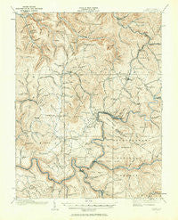
~ Cowen WV topo map, 1:62500 scale, 15 X 15 Minute, Historical, 1915, updated 1964
Cowen, West Virginia, USGS topographic map dated 1915.
Includes geographic coordinates (latitude and longitude). This topographic map is suitable for hiking, camping, and exploring, or framing it as a wall map.
Printed on-demand using high resolution imagery, on heavy weight and acid free paper, or alternatively on a variety of synthetic materials.
Topos available on paper, Waterproof, Poly, or Tyvek. Usually shipping rolled, unless combined with other folded maps in one order.
- Product Number: USGS-5415160
- Free digital map download (high-resolution, GeoPDF): Cowen, West Virginia (file size: 11 MB)
- Map Size: please refer to the dimensions of the GeoPDF map above
- Weight (paper map): ca. 55 grams
- Map Type: POD USGS Topographic Map
- Map Series: HTMC
- Map Verison: Historical
- Cell ID: 53015
- Scan ID: 253458
- Imprint Year: 1964
- Survey Year: 1915
- Datum: Unstated
- Map Projection: Polyconic
- Map published by United States Geological Survey
- Map Language: English
- Scanner Resolution: 600 dpi
- Map Cell Name: Cowen
- Grid size: 15 X 15 Minute
- Date on map: 1915
- Map Scale: 1:62500
- Geographical region: West Virginia, United States
Neighboring Maps:
All neighboring USGS topo maps are available for sale online at a variety of scales.
Spatial coverage:
Topo map Cowen, West Virginia, covers the geographical area associated the following places:
- Camden on Gauley - Allingdale - Tioga - Cottle - Delphi - Arcola - Marybill - Donald - Wainville - Donaldson - Woodbine - Cowen - Beaver - Strouds - Halo - Upperglade - Gauley Mills - Holcomb - Curtin - Nile - Glade View - Craigsville - Welch Glade - Boggs - Coe - Calvin - Weese
- Map Area ID: AREA38.538.25-80.75-80.5
- Northwest corner Lat/Long code: USGSNW38.5-80.75
- Northeast corner Lat/Long code: USGSNE38.5-80.5
- Southwest corner Lat/Long code: USGSSW38.25-80.75
- Southeast corner Lat/Long code: USGSSE38.25-80.5
- Northern map edge Latitude: 38.5
- Southern map edge Latitude: 38.25
- Western map edge Longitude: -80.75
- Eastern map edge Longitude: -80.5


