
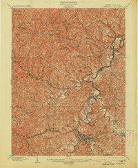
~ Clarksburg WV topo map, 1:62500 scale, 15 X 15 Minute, Historical, 1902, updated 1913
Clarksburg, West Virginia, USGS topographic map dated 1902.
Includes geographic coordinates (latitude and longitude). This topographic map is suitable for hiking, camping, and exploring, or framing it as a wall map.
Printed on-demand using high resolution imagery, on heavy weight and acid free paper, or alternatively on a variety of synthetic materials.
Topos available on paper, Waterproof, Poly, or Tyvek. Usually shipping rolled, unless combined with other folded maps in one order.
- Product Number: USGS-5415114
- Free digital map download (high-resolution, GeoPDF): Clarksburg, West Virginia (file size: 14 MB)
- Map Size: please refer to the dimensions of the GeoPDF map above
- Weight (paper map): ca. 55 grams
- Map Type: POD USGS Topographic Map
- Map Series: HTMC
- Map Verison: Historical
- Cell ID: 52639
- Scan ID: 253437
- Imprint Year: 1913
- Survey Year: 1901
- Datum: Unstated
- Map Projection: Unstated
- Map published by United States Geological Survey
- Map Language: English
- Scanner Resolution: 600 dpi
- Map Cell Name: Clarksburg
- Grid size: 15 X 15 Minute
- Date on map: 1902
- Map Scale: 1:62500
- Geographical region: West Virginia, United States
Neighboring Maps:
All neighboring USGS topo maps are available for sale online at a variety of scales.
Spatial coverage:
Topo map Clarksburg, West Virginia, covers the geographical area associated the following places:
- Long Run - Bridgeport - Dola - Sardis - Margaret - Haywood - Prospect Valley - Helens Run - Courtright - Glen Falls - Wallace - Cambria - Wilsonburg - Katy Lick - Seminole - Peora - Arbutus Park - Maken - Lumberport - Pine Bluff - Clarksburg - Brown - Anmoore - Chiefton - Stealey - Viropa - Big Run - Stringtown - Erie - Farnum - Despard - Dixie - Adamston - Gypsy - Rosebud - Alliance - Hepzibah - Hutchinson - Lodgeville - Willard - Nutter Fort - Chiefton - North View - Stonewood - Summit Park - Saltwell - Arlington - Bethlehem - Joetown - Festus - Montpelier - East View - Industrial - Owings - Reynoldsville - Mount Tabor - Shinnston - Oakdale - Glen Elk - Spelter - Laura Lee Mine - Cook Mine - Grangeville - Chestnut Hills - South Worthington - Bingamon - Wyatt - Highland - Broad Oaks - Robey - Dawmont - Four States - Enterprise - Oak Grove (historical) - Custer Addition - O'Neill - Worthington - Sturms Mill - Wolf Summit - Meadowbrook - Allied - Marshville - Edgewood - Olive - Jimtown - Sun Valley - Gore - Carolina - Idamay - Liberty
- Map Area ID: AREA39.539.25-80.5-80.25
- Northwest corner Lat/Long code: USGSNW39.5-80.5
- Northeast corner Lat/Long code: USGSNE39.5-80.25
- Southwest corner Lat/Long code: USGSSW39.25-80.5
- Southeast corner Lat/Long code: USGSSE39.25-80.25
- Northern map edge Latitude: 39.5
- Southern map edge Latitude: 39.25
- Western map edge Longitude: -80.5
- Eastern map edge Longitude: -80.25


