
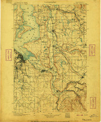
~ Tacoma WA topo map, 1:125000 scale, 30 X 30 Minute, Historical, 1900, updated 1906
Tacoma, Washington, USGS topographic map dated 1900.
Includes geographic coordinates (latitude and longitude). This topographic map is suitable for hiking, camping, and exploring, or framing it as a wall map.
Printed on-demand using high resolution imagery, on heavy weight and acid free paper, or alternatively on a variety of synthetic materials.
Topos available on paper, Waterproof, Poly, or Tyvek. Usually shipping rolled, unless combined with other folded maps in one order.
- Product Number: USGS-5411440
- Free digital map download (high-resolution, GeoPDF): Tacoma, Washington (file size: 10 MB)
- Map Size: please refer to the dimensions of the GeoPDF map above
- Weight (paper map): ca. 55 grams
- Map Type: POD USGS Topographic Map
- Map Series: HTMC
- Map Verison: Historical
- Cell ID: 66747
- Scan ID: 244180
- Imprint Year: 1906
- Survey Year: 1895
- Datum: Unstated
- Map Projection: Unstated
- Map published by United States Geological Survey
- Map Language: English
- Scanner Resolution: 600 dpi
- Map Cell Name: Tacoma
- Grid size: 30 X 30 Minute
- Date on map: 1900
- Map Scale: 1:125000
- Geographical region: Washington, United States
Neighboring Maps:
All neighboring USGS topo maps are available for sale online at a variety of scales.
Spatial coverage:
Topo map Tacoma, Washington, covers the geographical area associated the following places:
- SeaTac - Riverbend Mobile Home Park - Raineer View Mobile Home Community - Ponderosa Mobile Home Park - Shore Acres - Summerville Estates Mobile Home Park - Dieringer - Orchard Grove - Mount Tacoma Mobile Park - The Maples Mobile Home Park - Shady Woods East and West Mobile Home Park - North Puyallup - Fir Meadows Mobile Home Park - Fairfield Estates Mobile Home Park - Ohana Estates Mobile Home Park - Tukwila - Noble - Evergreen Ridge Mobile Home Park - Tall Cedars Mobile Court - Sumner - Bonel Mobile Manor - Glen Acres - Rosehilla - Vue Mobile Home Park - Timberlane - Shady Haven Mobile Home Park - Spanaway - Summer Villa Estates Mobile Home Park - Summit - Des Moines - Crestwood Mobile Home Park - Midland - Christopher - Buenna - Elmwood Mobile Home Park - Double A Mobile Manor - Valley Mobile Manor - River Mobile Home Park - Emerald Crest Mobile Home Park - Puyallup River Junction - Puget View Mobile Home Park - Willo Vista Mobile Estates - North Hill - Highlands Park - Twin Flags Mobile Home Community - Fairwood - Tyee Valley Mobile Manor - Lea Hill - Mirror Lake - Mileta - Evansville - Mountain View Estates Mobile Home Park - Wonderland Mobile Homes - Charwood Mobile Home Park - McMillin - Lakeview - Rocky Ridge - Mountain Valley Mobile Home Park - Orting - View Crest Mobile Home Park - Midway Mobile Mansions - Cherrywood Mobile Home Manor Sewage Treatment Plant - Whispering Firs Mobile Home Park - Thomas - Meeker - Caledonia - Park Place Estates Manufactured Home Park - Empire View Mobile Home Park - Portage - Stuck - Dilworth - Silvercrest Mobile Home Park - Buckley - Prairie Ridge - Manor Mobile Home Park - Milton - Heather Hills Mobile Home Park - San Souci Mobile Estates - Burton - Cherrywood Mobile Manor - Cebalop (historical) - Federal Way - Burnett - Bow Lake Residential Mobile Home Community - Five Corners - Laurelwood Mobile Home Park - Loveland - Tacoma Country Estates Mobile Home Park - South Tacoma - Kitts Corner - Oaknoll Trailer Park - Pinecrest Mobile Home Park - Bethel Park - Graham - North West Mobile Home Park - Canyon Terrace Mobile Estates - Delray Mobile Home Park - Browns Point - Meridian Mobile Estates - Riverton
- Map Area ID: AREA47.547-122.5-122
- Northwest corner Lat/Long code: USGSNW47.5-122.5
- Northeast corner Lat/Long code: USGSNE47.5-122
- Southwest corner Lat/Long code: USGSSW47-122.5
- Southeast corner Lat/Long code: USGSSE47-122
- Northern map edge Latitude: 47.5
- Southern map edge Latitude: 47
- Western map edge Longitude: -122.5
- Eastern map edge Longitude: -122


