
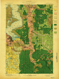
~ Tacoma WA topo map, 1:125000 scale, 30 X 30 Minute, Historical, 1897
Tacoma, Washington, USGS topographic map dated 1897.
Includes geographic coordinates (latitude and longitude). This topographic map is suitable for hiking, camping, and exploring, or framing it as a wall map.
Printed on-demand using high resolution imagery, on heavy weight and acid free paper, or alternatively on a variety of synthetic materials.
Topos available on paper, Waterproof, Poly, or Tyvek. Usually shipping rolled, unless combined with other folded maps in one order.
- Product Number: USGS-5411434
- Free digital map download (high-resolution, GeoPDF): Tacoma, Washington (file size: 9 MB)
- Map Size: please refer to the dimensions of the GeoPDF map above
- Weight (paper map): ca. 55 grams
- Map Type: POD USGS Topographic Map
- Map Series: HTMC
- Map Verison: Historical
- Cell ID: 66747
- Scan ID: 244177
- Woodland Tint: Yes
- Survey Year: 1897
- Datum: Unstated
- Map Projection: Unstated
- Map published by United States Geological Survey
- Map Language: English
- Scanner Resolution: 600 dpi
- Map Cell Name: Tacoma
- Grid size: 30 X 30 Minute
- Date on map: 1897
- Map Scale: 1:125000
- Geographical region: Washington, United States
Neighboring Maps:
All neighboring USGS topo maps are available for sale online at a variety of scales.
Spatial coverage:
Topo map Tacoma, Washington, covers the geographical area associated the following places:
- East Renton Highlands - Upper Fairfax - Oaknoll Trailer Park - Seola Beach - Hidden Glen Mobile Home Park - Vashon - Fairfax - Pantera Lago Estates Mobile Home Park - Rancho Villa Mobile Home Park - Twin Flags Mobile Home Community - Cascade - Highline - Klahanie - Bethel Park - Leisure Estates Mobile Home Park - Mountplains Rainier Mobile Home Park - Cedar View - Zenith - Pleasant Valley Manor Mobile Home Park - Henrys - Hongking (historical) - Francis Mobile Home Court - Maple Valley - Weller Martin Mobile Home Park - Newaukum - Tanwax - Carbonado - Ponderosa Estates - Park Place Estates Manufactured Home Park - Country Road Estates Mobile Home Park - Canterbury Estates Mobile Home Park - The Maples Mobile Home Park - Danville - Adelaide - Alderton - South Hill Palisade Mobile Home Park - Sound Vista Mobile Home Park - Mount View - Don Juan Mobile Home Park - Valley View Mobile Home Park - Prairie Ridge - Parklane Mobile Estates - Mountain Valley Mobile Home Park - South Hill - Loveland Mobile Estates - Manzanita - Dieringer - Empire View Mobile Home Park - Boulevard Park - Rio Verde Mobile Estates - Harbor Heights - Fox Chase Mobile Home Park - Wilkeson - Mountain View Estates Mobile Home Park - Timberlane - Walnut Grove Mobile Home Park - Highlands Park - North Hill - Fern Hill - Old Tacoma - Berkeley - Willo Vista Mobile Estates - Magnolia Beach - Cedarbrook Mobile Home Park - Vermontville (historical) - Caledonia - Wynaco - Shawnee - Southgate Mobile Home Park - Monta Vista - Cebalop (historical) - Laurelwood Valley Mobile Home Park - One Hundred Thirty - Eighth Park Mobile Estates - Brookdale - Cedar Mountain - McVan - Highline Park Mobile Home Park - Raineer View Mobile Home Community - Wildwood Mobile Home Estates - Crystal Spring Mobile Home Estates - Country Mobile Estates - Lea Hill - Burien - Benson Village Mobile Home Park - The River Mobile Estates - Oakridge Manor Mobile Home Park - One Hundred One Pines - Coach Country Corral Mobile Home Park - Cherrywood Mobile Home Manor Sewage Treatment Plant - Allison - Meridian Mobile Estates - Tiger Mountain Mobile Home Park - Orchard Trailer Park - Wilderness Village - Midland - Vantage Glen Mobile Home Park - Mirrormount Estates - Golden Horseshoe Mobile Home Park - Dash Point - McMillin
- Map Area ID: AREA47.547-122.5-122
- Northwest corner Lat/Long code: USGSNW47.5-122.5
- Northeast corner Lat/Long code: USGSNE47.5-122
- Southwest corner Lat/Long code: USGSSW47-122.5
- Southeast corner Lat/Long code: USGSSE47-122
- Northern map edge Latitude: 47.5
- Southern map edge Latitude: 47
- Western map edge Longitude: -122.5
- Eastern map edge Longitude: -122


