
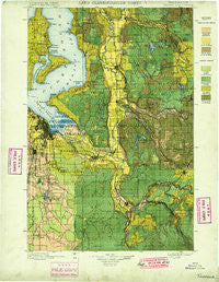
~ Tacoma WA topo map, 1:125000 scale, 30 X 30 Minute, Historical, 1900
Tacoma, Washington, USGS topographic map dated 1900.
Includes geographic coordinates (latitude and longitude). This topographic map is suitable for hiking, camping, and exploring, or framing it as a wall map.
Printed on-demand using high resolution imagery, on heavy weight and acid free paper, or alternatively on a variety of synthetic materials.
Topos available on paper, Waterproof, Poly, or Tyvek. Usually shipping rolled, unless combined with other folded maps in one order.
- Product Number: USGS-5411432
- Free digital map download (high-resolution, GeoPDF): Tacoma, Washington (file size: 14 MB)
- Map Size: please refer to the dimensions of the GeoPDF map above
- Weight (paper map): ca. 55 grams
- Map Type: POD USGS Topographic Map
- Map Series: HTMC
- Map Verison: Historical
- Cell ID: 66747
- Scan ID: 244176
- Woodland Tint: Yes
- Survey Year: 1897
- Datum: Unstated
- Map Projection: Unstated
- Map published by United States Geological Survey
- Map Language: English
- Scanner Resolution: 600 dpi
- Map Cell Name: Tacoma
- Grid size: 30 X 30 Minute
- Date on map: 1900
- Map Scale: 1:125000
- Geographical region: Washington, United States
Neighboring Maps:
All neighboring USGS topo maps are available for sale online at a variety of scales.
Spatial coverage:
Topo map Tacoma, Washington, covers the geographical area associated the following places:
- Manzanita - Auburn Green Mobile Home Park - Camelot Square Mobile Home Park - Hillsdale - Maple Hills - Mirrormount Estates - Five Corners - Manor Mobile Home Park - Auburn - Redondo - Fairfax - Riverton - Wabash - Des Moines Estates Mobile Home Park - Vaugans Mobile Home Park - Shilo Mobile Home Park - Killarney Woods Mobile Home Park - Country West Mobile Home Park - Dorre Don - Danville - South Hill Palisade Mobile Home Park - Americana Mobile Home Park - Shady Woods East and West Mobile Home Park - Coach Country Corral Mobile Home Park - Elk Plain - East Renton Highlands - Carriage Mobile Home Court - Orchard Trailer Park - Cherrywood Mobile Manor - Jovita - Kent - Tiger Mountain Mobile Home Park - Sunnydale - Graham - Burton - East Hill - Fairfield Estates Mobile Home Park - Fairlane Terrace Mobile Home Park - McMillin - Pine Terrace Mobile Home Park - Tahoma - Greenwood Mobile Home Park - Charleton Lake Estates Mobile Home Park - Lone Cedar Mobile Home Park - Golden Rose Mobile Home Park - Evergreen Manor Mobile Home Park - Brookdale - Cottonwood Mobile Home Park - Lea Hill - Tanwax - Meadowbrook Mobile Home Park - Shawnee - Ponderosa Estates - Shafrans Mobile Estate - Shady Haven Mobile Home Park - Meeker - Parklane Court Mobile Home Park - Mount View - Summer Villa Estates Mobile Home Park - Valleybrook Mobile Home Park - Diru Mobile Home Park - Laurelwood Valley Mobile Home Park - Mirror Lake - Monta Vista - Golden Valley Mobile Home Park - Meridian Heights - Cedarhurst - Valley View Mobile Home Park - Firwood Mobile Home Park - Mountplains Rainier Mobile Home Park - Rancho Villa Mobile Home Park - Cebalop (historical) - Highline - Crestwood Mobile Home Park - Evergreen Ridge Mobile Home Park - Willo Vista Mobile Estates - Skyway Mobile Home Park - Shorewood - Berrydale - Bonel Mobile Manor - Golden Horseshoe Mobile Home Park - McMillan Village Mobile Home Park - Maple Valley - Maplewood Heights - North Puyallup - Raeco - Silvercrest Mobile Home Park - Raineer View Mobile Home Community - Belmor Mobile Home Park - Country Mobile Estates - Quiet Meadows Mobile Park - SeaTac - Des Moines - Bonney Lake - Maury - Walnut Grove Mobile Home Park - Viking Mobile Home Court - Orillia - Deer Run Mobile Home Park - Bonavilla Mobile Home Park
- Map Area ID: AREA47.547-122.5-122
- Northwest corner Lat/Long code: USGSNW47.5-122.5
- Northeast corner Lat/Long code: USGSNE47.5-122
- Southwest corner Lat/Long code: USGSSW47-122.5
- Southeast corner Lat/Long code: USGSSE47-122
- Northern map edge Latitude: 47.5
- Southern map edge Latitude: 47
- Western map edge Longitude: -122.5
- Eastern map edge Longitude: -122


